Santana de Parnaíba geodata
Santana de Parnaíba (São Paulo) is a populated place; located in Brazil in America/Sao_Paulo (GMT-3) time zone. With population of 98,989 people, there are 234 cities with bigger population in this country. Compared to other cities in Brazil, 82.3% of cities are located further ↑North; 57.9% of cities are located further →East and 81.5% of cities have lower elevation than Santana de Parnaíba. Note1


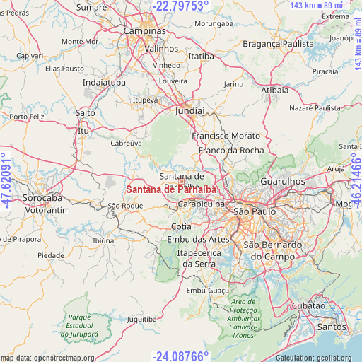
Santana de Parnaíba GPS coordinates[2]
23° 26' 39.012" South, 46° 55' 4.008" West
| Map corner | latitude | longitude |
|---|---|---|
| Upper-left | -22.79753°, | -47.62091° |
| Center: | -23.44417°, | -46.91778° |
| Lower-right: | -24.08766°, | -46.21466° |
| Map W x H: | 143.4×143.5 km | = 89.1×89.2mi |
| max Lat: | 2.81972° ⇑82.3% North |
| Santana de Parnaíba: | -23.44417° |
| min Lat: | ⇓17.7% South -33.69111° |
| min Long | Santana de Parn | max Long |
| -72.89583° | -46.91778° | -32.41083° |
| W 42.1%⇐ | ⇒57.9% E |
Elevation
Elevation of Santana de Parnaíba is 711 m = 2333 ft, and this is 330.1 m = 1083 ft above average elevation for this country.
| Max E: |
1603 m = 5259 ft | 18.5% |
| Santana de Parnaíba | 711 m 2333 ft | |
| Avg. | 380.9 m = 1250 ft | |
Min E: |
0 m = 0 ft | 81.5% |
See also: Santana de Parnaíba elevation on elevation.city.
Geographical zone
Santana de Parnaíba is located in South temperate zone (between Tropic of Capricorn and the Antarctic Circle). Distance of this Southern Tropic circle is 0.8 km =0.5 mi to North.| Distance of | km | miles | from Santana de Parnaíba |
|---|---|---|---|
| Equator | 2606.7 | 1619.7 | to North |
| Tropic Capricorn | 0.8 | 0.5 | to North |
| Antarctic Circle | 4794.4 | 2979.1 | to South |
| South Pole | 7400.3 | 4598.3 | to South |


Nearby cities:
15 places around Santana de Parnaíba: (largest is in red/bold)
• Barueri
8.5 km =5.3 mi,  150°
150°
• Caieiras
20.2 km =12.6 mi,  63°
63°
• Cajamar
10.6 km =6.6 mi,  23°
23°
• Carapicuíba
12.1 km =7.5 mi,  135°
135°
• Cotia
17.8 km =11.1 mi,  180°
180°
• Embu
23.7 km =14.7 mi,  163°
163°
• Francisco Morato
25.2 km =15.7 mi,  44°
44°
• Franco da Rocha
23.8 km =14.8 mi, 55°
• Itapevi
11.8 km =7.3 mi,  188°
188°
• Jandira
9.4 km =5.8 mi,  170°
170°
• Osasco
16.2 km =10.1 mi,  127°
127°
• Pirapora do Bom Jesus
10.1 km =6.3 mi,  301°
301°
• São Roque
24.1 km =15 mi,  246°
246°
• Taboão da Serra
24 km =14.9 mi, 147°
• Vargem Grande Paulista
20.9 km =13 mi,  212°
212°
Sources, notices
• [Note1] Compared only with cities in Brazil existing in our database
• [Src1] Map data: © OpenStreetMap contributors (CC-BY-SA)
• [Src2] Other city data from geonames.org with taken over terms of usage.
• [Src3] Geographical zone / Annual Mean Temperature by Robert A. Rohde @ Wikipedia
