Riachão das Neves geodata
Riachão das Neves (Bahia) is a populated place; located in Brazil in America/Bahia (GMT-3) time zone. With population of 11,236 people, there are 1543 cities with bigger population in this country. Compared to other cities in Brazil, 62.9% of cities are located further ↓South; 51.8% of cities are located further ←West and 62.5% of cities have lower elevation than Riachão das Neves. Note1


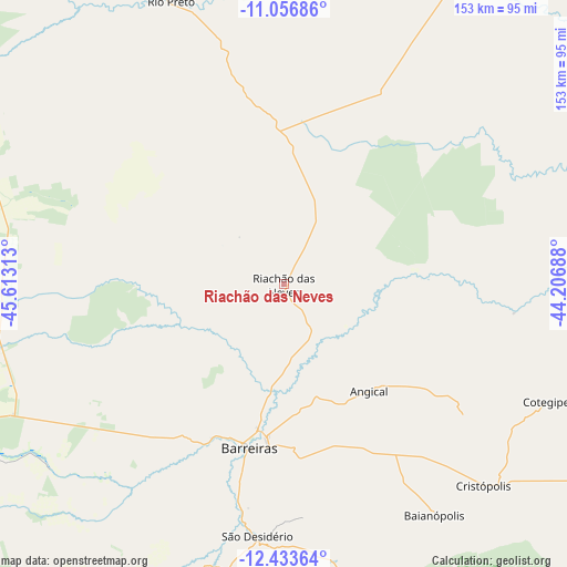
Riachão das Neves GPS coordinates[2]
11° 44' 45.996" South, 44° 54' 36" West
| Map corner | latitude | longitude |
|---|---|---|
| Upper-left | -11.05686°, | -45.61313° |
| Center: | -11.74611°, | -44.91° |
| Lower-right: | -12.43364°, | -44.20688° |
| Map W x H: | 153.1×153.1 km | = 95.1×95.1mi |
| max Lat: | 2.81972° ⇑37.1% North |
| Riachão das Neves: | -11.74611° |
| min Lat: | ⇓62.9% South -33.69111° |
| min Long | Riachão das Ne | max Long |
| -72.89583° | -44.91° | -32.41083° |
| W 51.8%⇐ | ⇒48.2% E |
Elevation
Elevation of Riachão das Neves is 503 m = 1650 ft, and this is 122.1 m = 401 ft above average elevation for this country.
| Max E: |
1603 m = 5259 ft | 37.5% |
| Riachão das Neves | 503 m 1650 ft | |
| Avg. | 380.9 m = 1250 ft | |
Min E: |
0 m = 0 ft | 62.5% |
See also: Brazil elevation on elevation.city.
Geographical zone
Riachão das Neves is located in South Torrid zone (between Equator and Tropic of Capricorn). Distance of this Southern Tropic circle is 1299.9 km =807.7 mi to South.| Distance of | km | miles | from Riachão das Neves |
|---|---|---|---|
| Equator | 1306 | 811.5 | to North |
| Tropic Capricorn | 1299.9 | 807.7 | to South |
| Antarctic Circle | 6095.1 | 3787.3 | to South |
| South Pole | 8701 | 5406.5 | to South |


Nearby cities:
15 places around Riachão das Neves: (largest is in red/bold)
• Barra
206.1 km =128.1 mi,  69°
69°
• Barreiras
46 km =28.6 mi,  190°
190°
• Beira Rio
241.1 km =149.8 mi,  103°
103°
• Bom Jesus da Lapa
233.2 km =144.9 mi,  136°
136°
• Campos Belos
247.9 km =154 mi,  234°
234°
• Correntina
180.1 km =111.9 mi,  170°
170°
• Formosa do Rio Preto
83.5 km =51.9 mi,  338°
338°
• Gilbués
218.1 km =135.5 mi,  347°
347°
• Ibotirama
190.1 km =118.1 mi, 104°
• Oliveira dos Brejinhos
228 km =141.7 mi,  106°
106°
• Paratinga
214.9 km =133.5 mi,  119°
119°
• Santa Maria da Vitória
198.2 km =123.2 mi,  157°
157°
• São Desidério
69 km =42.9 mi, 185°
• São Domingos
239 km =148.5 mi,  219°
219°
• Taguatinga
181.3 km =112.7 mi,  246°
246°
Sources, notices
• [Note1] Compared only with cities in Brazil existing in our database
• [Src1] Map data: © OpenStreetMap contributors (CC-BY-SA)
• [Src2] Other city data from geonames.org with taken over terms of usage.
• [Src3] Geographical zone / Annual Mean Temperature by Robert A. Rohde @ Wikipedia
