Taguatinga geodata
Taguatinga (Tocantins) is a seat of a second-order administrative division; located in Brazil in America/Araguaina (GMT-3) time zone. With population of 13,711 people, there are 1314 cities with bigger population in this country. Compared to other cities in Brazil, 61.5% of cities are located further ↓South; 54.7% of cities are located further →East and 72.6% of cities have lower elevation than Taguatinga. Note1


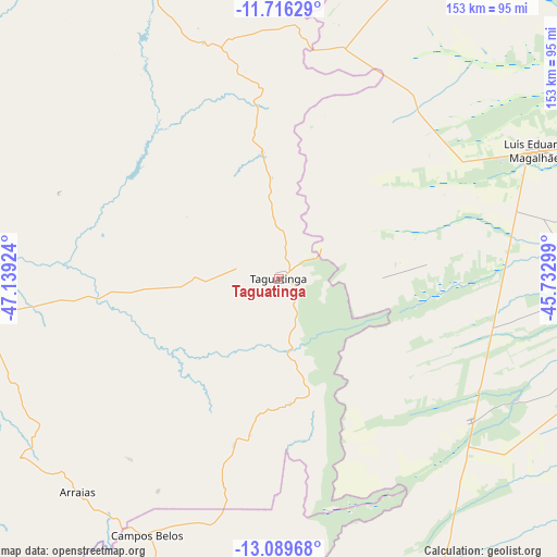
Taguatinga GPS coordinates[2]
12° 24' 14.004" South, 46° 26' 9.996" West
| Map corner | latitude | longitude |
|---|---|---|
| Upper-left | -11.71629°, | -47.13924° |
| Center: | -12.40389°, | -46.43611° |
| Lower-right: | -13.08968°, | -45.73299° |
| Map W x H: | 152.7×152.7 km | = 94.9×94.9mi |
| max Lat: | 2.81972° ⇑38.5% North |
| Taguatinga: | -12.40389° |
| min Lat: | ⇓61.5% South -33.69111° |
| min Long | Taguatinga | max Long |
| -72.89583° | -46.43611° | -32.41083° |
| W 45.3%⇐ | ⇒54.7% E |
Elevation
Elevation of Taguatinga is 599 m = 1965 ft, and this is 218.1 m = 716 ft above average elevation for this country.
| Max E: |
1603 m = 5259 ft | 27.4% |
| Taguatinga | 599 m 1965 ft | |
| Avg. | 380.9 m = 1250 ft | |
Min E: |
0 m = 0 ft | 72.6% |
See also: Brazil elevation on elevation.city.
Geographical zone
Taguatinga is located in South Torrid zone (between Equator and Tropic of Capricorn). Distance of this Southern Tropic circle is 1226.7 km =762.2 mi to South.| Distance of | km | miles | from Taguatinga |
|---|---|---|---|
| Equator | 1379.2 | 857 | to North |
| Tropic Capricorn | 1226.7 | 762.2 | to South |
| Antarctic Circle | 6022 | 3741.9 | to South |
| South Pole | 8627.9 | 5361.1 | to South |


Nearby cities:
15 places around Taguatinga: (largest is in red/bold)
• Alvorada
292 km =181.4 mi,  268°
268°
• Arraias
80.1 km =49.8 mi,  222°
222°
• Barreiras
159.6 km =99.2 mi,  79°
79°
• Campos Belos
79.2 km =49.2 mi,  207°
207°
• Cavalcante
190.4 km =118.3 mi, 215°
• Correntina
221.3 km =137.5 mi,  118°
118°
• Formosa do Rio Preto
202.6 km =125.9 mi,  41°
41°
• Gurupi
295.9 km =183.9 mi,  284°
284°
• Iaciara
189.3 km =117.6 mi,  186°
186°
• Minaçu
230.5 km =143.2 mi,  236°
236°
• Posse
188 km =116.8 mi,  177°
177°
• Riachão das Neves
181.3 km =112.7 mi,  66°
66°
• Santa Maria da Vitória
266.1 km =165.3 mi,  114°
114°
• São Desidério
158.9 km =98.7 mi,  88°
88°
• São Domingos
111.3 km =69.2 mi,  173°
173°
Sources, notices
• [Note1] Compared only with cities in Brazil existing in our database
• [Src1] Map data: © OpenStreetMap contributors (CC-BY-SA)
• [Src2] Other city data from geonames.org with taken over terms of usage.
• [Src3] Geographical zone / Annual Mean Temperature by Robert A. Rohde @ Wikipedia
