Realeza geodata
Realeza (Paraná) is a populated place; located in Brazil in America/Sao_Paulo (GMT-3) time zone. With population of 10,389 people, there are 1611 cities with bigger population in this country. Compared to other cities in Brazil, 89.2% of cities are located further ↑North; 91.6% of cities are located further →East and 58.7% of cities have lower elevation than Realeza. Note1


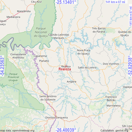
Realeza GPS coordinates[2]
25° 46' 8.004" South, 53° 31' 57" West
| Map corner | latitude | longitude |
|---|---|---|
| Upper-left | -25.13401°, | -54.23563° |
| Center: | -25.76889°, | -53.5325° |
| Lower-right: | -26.40039°, | -52.82938° |
| Map W x H: | 140.8×140.8 km | = 87.5×87.5mi |
| max Lat: | 2.81972° ⇑89.2% North |
| Realeza: | -25.76889° |
| min Lat: | ⇓10.8% South -33.69111° |
| min Long | Realeza | max Long |
| -72.89583° | -53.5325° | -32.41083° |
| W 8.4%⇐ | ⇒91.6% E |
Elevation
Elevation of Realeza is 462 m = 1516 ft, and this is 81.1 m = 266 ft above average elevation for this country.
| Max E: |
1603 m = 5259 ft | 41.3% |
| Realeza | 462 m 1516 ft | |
| Avg. | 380.9 m = 1250 ft | |
Min E: |
0 m = 0 ft | 58.7% |
See also: Brazil elevation on elevation.city.
Geographical zone
Realeza is located in South temperate zone (between Tropic of Capricorn and the Antarctic Circle). Distance of this Southern Tropic circle is 259.3 km =161.1 mi to North.| Distance of | km | miles | from Realeza |
|---|---|---|---|
| Equator | 2865.2 | 1780.4 | to North |
| Tropic Capricorn | 259.3 | 161.1 | to North |
| Antarctic Circle | 4535.9 | 2818.5 | to South |
| South Pole | 7141.8 | 4437.7 | to South |


Nearby cities:
15 places around Realeza: (largest is in red/bold)
• Ampére
17.3 km =10.7 mi,  159°
159°
• Cascavel
90.7 km =56.4 mi,  4°
4°
• Chopinzinho
101.5 km =63.1 mi,  95°
95°
• Corbélia
110.2 km =68.5 mi,  11°
11°
• Coronel Vivida
99.3 km =61.7 mi, 103°
• Dois Vizinhos
47.8 km =29.7 mi,  85°
85°
• Foz do Iguaçu
108.6 km =67.5 mi,  283°
283°
• Francisco Beltrão
59 km =36.7 mi,  126°
126°
• Guaraniaçu
99.2 km =61.6 mi,  41°
41°
• Matelândia
74.9 km =46.5 mi,  321°
321°
• Medianeira
77.1 km =47.9 mi,  313°
313°
• Pato Branco
100.2 km =62.3 mi,  120°
120°
• Santo Antônio do Sudoeste
39 km =24.2 mi,  209°
209°
• São Lourenço do Oeste
94.5 km =58.7 mi, 133°
• São Miguel do Iguaçu
84.8 km =52.7 mi,  303°
303°
Sources, notices
• [Note1] Compared only with cities in Brazil existing in our database
• [Src1] Map data: © OpenStreetMap contributors (CC-BY-SA)
• [Src2] Other city data from geonames.org with taken over terms of usage.
• [Src3] Geographical zone / Annual Mean Temperature by Robert A. Rohde @ Wikipedia
