Foz do Iguaçu geodata
Foz do Iguaçu (Paraná) is a seat of a second-order administrative division; located in Brazil in America/Sao_Paulo (GMT-3) time zone. With population of 293,523 people, there are 74 cities with bigger population in this country. Compared to other cities in Brazil, 89% of cities are located further ↑North; 93.5% of cities are located further →East and 63.8% of cities have higher elevation than Foz do Iguaçu. Note1


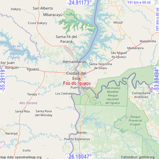
Foz do Iguaçu GPS coordinates[2]
25° 32' 52.008" South, 54° 35' 17.016" West
| Map corner | latitude | longitude |
|---|---|---|
| Upper-left | -24.91173°, | -55.29119° |
| Center: | -25.54778°, | -54.58806° |
| Lower-right: | -26.18047°, | -53.88494° |
| Map W x H: | 141.1×141.1 km | = 87.7×87.7mi |
| max Lat: | 2.81972° ⇑89% North |
| Foz do Iguaçu: | -25.54778° |
| min Lat: | ⇓11% South -33.69111° |
| min Long | Foz do Iguaçu | max Long |
| -72.89583° | -54.58806° | -32.41083° |
| W 6.5%⇐ | ⇒93.5% E |
Elevation
Elevation of Foz do Iguaçu is 179 m = 587 ft, and this is 201.9 m = 662 ft below average elevation for this country.
| Max E: |
1603 m = 5259 ft | 63.8% |
| Avg. | 380.9 m = 1250 ft | |
| Foz do Iguaçu | 179 m = 587 ft | |
Min E: |
0 m = 0 ft | 36.2% |
See also: Foz do Iguaçu elevation on elevation.city.
Geographical zone
Foz do Iguaçu is located in South temperate zone (between Tropic of Capricorn and the Antarctic Circle). Distance of this Southern Tropic circle is 234.7 km =145.8 mi to North.| Distance of | km | miles | from Foz do Iguaçu |
|---|---|---|---|
| Equator | 2840.6 | 1765.1 | to North |
| Tropic Capricorn | 234.7 | 145.8 | to North |
| Antarctic Circle | 4560.5 | 2833.8 | to South |
| South Pole | 7166.4 | 4453 | to South |


Nearby cities:
15 places around Foz do Iguaçu: (largest is in red/bold)
• Ampére
118.9 km =73.9 mi,  110°
110°
• Cascavel
131.6 km =81.8 mi,  59°
59°
• Corbélia
153.5 km =95.4 mi, 57°
• Dois Vizinhos
154.8 km =96.2 mi,  97°
97°
• Francisco Beltrão
164.5 km =102.2 mi, 111°
• Guaraniaçu
178.9 km =111.2 mi,  73°
73°
• Iporã
193.6 km =120.3 mi,  27°
27°
• Marechal Cândido Rondon
122.6 km =76.2 mi, 25°
• Matelândia
68.5 km =42.6 mi, 60°
• Medianeira
57 km =35.4 mi, 60°
• Palotina
159.5 km =99.1 mi, 28°
• Realeza
108.6 km =67.5 mi, 103°
• Santo Antônio do Sudoeste
104.3 km =64.8 mi,  124°
124°
• São Miguel do Iguaçu
41.6 km =25.8 mi, 57°
• Toledo
125.8 km =78.2 mi,  42°
42°
In other languages:
- In Spanish: Foz de Iguazu
- In German: Foz do Iguaçu, Foz do Iguacu
- In Russian: Фос-ду-Игуасу
- In Chinese: 伊瓜苏
Sources, notices
• [Note1] Compared only with cities in Brazil existing in our database
• [Src1] Map data: © OpenStreetMap contributors (CC-BY-SA)
• [Src2] Other city data from geonames.org with taken over terms of usage.
• [Src3] Geographical zone / Annual Mean Temperature by Robert A. Rohde @ Wikipedia
