Cascavel geodata
Cascavel (Paraná) is a populated place; located in Brazil in America/Sao_Paulo (GMT-3) time zone. With population of 257,172 people, there are 84 cities with bigger population in this country. Compared to other cities in Brazil, 87.7% of cities are located further ↑North; 91.4% of cities are located further →East and 88.1% of cities have lower elevation than Cascavel. Note1


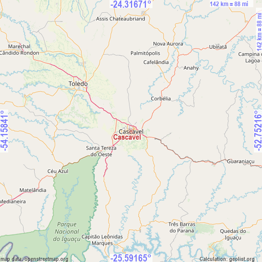
Cascavel GPS coordinates[2]
24° 57' 20.988" South, 53° 27' 19.008" West
| Map corner | latitude | longitude |
|---|---|---|
| Upper-left | -24.31671°, | -54.15841° |
| Center: | -24.95583°, | -53.45528° |
| Lower-right: | -25.59165°, | -52.75216° |
| Map W x H: | 141.8×141.8 km | = 88.1×88.1mi |
| max Lat: | 2.81972° ⇑87.7% North |
| Cascavel: | -24.95583° |
| min Lat: | ⇓12.3% South -33.69111° |
| min Long | Cascavel | max Long |
| -72.89583° | -53.45528° | -32.41083° |
| W 8.6%⇐ | ⇒91.4% E |
Elevation
Elevation of Cascavel is 786 m = 2579 ft, and this is 405.1 m = 1329 ft above average elevation for this country.
| Max E: |
1603 m = 5259 ft | 11.9% |
| Cascavel | 786 m 2579 ft | |
| Avg. | 380.9 m = 1250 ft | |
Min E: |
0 m = 0 ft | 88.1% |
See also: Cascavel elevation on elevation.city.
Geographical zone
Cascavel is located in South temperate zone (between Tropic of Capricorn and the Antarctic Circle). Distance of this Southern Tropic circle is 168.9 km =104.9 mi to North.| Distance of | km | miles | from Cascavel |
|---|---|---|---|
| Equator | 2774.8 | 1724.2 | to North |
| Tropic Capricorn | 168.9 | 104.9 | to North |
| Antarctic Circle | 4626.3 | 2874.6 | to South |
| South Pole | 7232.2 | 4493.9 | to South |


Nearby cities:
15 places around Cascavel: (largest is in red/bold)
• Alto Piquiri
103.2 km =64.1 mi,  0°
0°
• Ampére
106.7 km =66.3 mi,  180°
180°
• Corbélia
23 km =14.3 mi,  40°
40°
• Dois Vizinhos
95.3 km =59.2 mi,  155°
155°
• Guaraniaçu
60.3 km =37.5 mi,  105°
105°
• Iporã
108.9 km =67.7 mi,  346°
346°
• Laranjeiras do Sul
116 km =72.1 mi,  115°
115°
• Marechal Cândido Rondon
75.3 km =46.8 mi,  306°
306°
• Matelândia
63 km =39.1 mi,  239°
239°
• Medianeira
74.5 km =46.3 mi, 239°
• Moreira Sales
109.2 km =67.9 mi,  24°
24°
• Palotina
84.2 km =52.3 mi,  332°
332°
• Realeza
90.7 km =56.4 mi, 184°
• São Miguel do Iguaçu
90 km =55.9 mi, 241°
• Toledo
39.6 km =24.6 mi, 312°
Sources, notices
• [Note1] Compared only with cities in Brazil existing in our database
• [Src1] Map data: © OpenStreetMap contributors (CC-BY-SA)
• [Src2] Other city data from geonames.org with taken over terms of usage.
• [Src3] Geographical zone / Annual Mean Temperature by Robert A. Rohde @ Wikipedia
