Guaraniaçu geodata
Guaraniaçu (Paraná) is a populated place; located in Brazil in America/Sao_Paulo (GMT-3) time zone. With population of 7,781 people, there are 1785 cities with bigger population in this country. Compared to other cities in Brazil, 87.9% of cities are located further ↑North; 90.2% of cities are located further →East and 90.3% of cities have lower elevation than Guaraniaçu. Note1


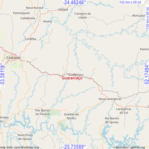
Guaraniaçu GPS coordinates[2]
25° 6' 2.988" South, 52° 52' 41.016" West
| Map corner | latitude | longitude |
|---|---|---|
| Upper-left | -24.46246°, | -53.58119° |
| Center: | -25.10083°, | -52.87806° |
| Lower-right: | -25.73589°, | -52.17494° |
| Map W x H: | 141.6×141.6 km | = 88×88mi |
| max Lat: | 2.81972° ⇑87.9% North |
| Guaraniaçu: | -25.10083° |
| min Lat: | ⇓12.1% South -33.69111° |
| min Long | Guaraniaçu | max Long |
| -72.89583° | -52.87806° | -32.41083° |
| W 9.8%⇐ | ⇒90.2% E |
Elevation
Elevation of Guaraniaçu is 819 m = 2687 ft, and this is 438.1 m = 1437 ft above average elevation for this country.
| Max E: |
1603 m = 5259 ft | 9.7% |
| Guaraniaçu | 819 m 2687 ft | |
| Avg. | 380.9 m = 1250 ft | |
Min E: |
0 m = 0 ft | 90.3% |
See also: Brazil elevation on elevation.city.
Geographical zone
Guaraniaçu is located in South temperate zone (between Tropic of Capricorn and the Antarctic Circle). Distance of this Southern Tropic circle is 185 km =115 mi to North.| Distance of | km | miles | from Guaraniaçu |
|---|---|---|---|
| Equator | 2791 | 1734.2 | to North |
| Tropic Capricorn | 185 | 115 | to North |
| Antarctic Circle | 4610.2 | 2864.6 | to South |
| South Pole | 7216.1 | 4483.9 | to South |


Nearby cities:
15 places around Guaraniaçu: (largest is in red/bold)
• Ampére
108.4 km =67.4 mi,  213°
213°
• Cascavel
60.3 km =37.5 mi,  285°
285°
• Chopinzinho
91.2 km =56.7 mi,  157°
157°
• Corbélia
54.7 km =34 mi,  307°
307°
• Coronel Vivida
102.6 km =63.8 mi, 162°
• Dois Vizinhos
72.6 km =45.1 mi,  194°
194°
• Francisco Beltrão
110.4 km =68.6 mi, 189°
• Laranjeiras do Sul
57.6 km =35.8 mi,  126°
126°
• Matelândia
113.6 km =70.6 mi,  262°
262°
• Medianeira
124.2 km =77.2 mi, 259°
• Moreira Sales
116.2 km =72.2 mi,  353°
353°
• Pato Branco
127.1 km =79 mi,  170°
170°
• Pitanga
118.9 km =73.9 mi,  71°
71°
• Realeza
99.2 km =61.6 mi,  221°
221°
• Toledo
97.3 km =60.5 mi,  296°
296°
Sources, notices
• [Note1] Compared only with cities in Brazil existing in our database
• [Src1] Map data: © OpenStreetMap contributors (CC-BY-SA)
• [Src2] Other city data from geonames.org with taken over terms of usage.
• [Src3] Geographical zone / Annual Mean Temperature by Robert A. Rohde @ Wikipedia
