Francisco Beltrão geodata
Francisco Beltrão (Paraná) is a populated place; located in Brazil in America/Sao_Paulo (GMT-3) time zone. With population of 57,618 people, there are 380 cities with bigger population in this country. Compared to other cities in Brazil, 89.6% of cities are located further ↑North; 90.5% of cities are located further →East and 69.1% of cities have lower elevation than Francisco Beltrão. Note1


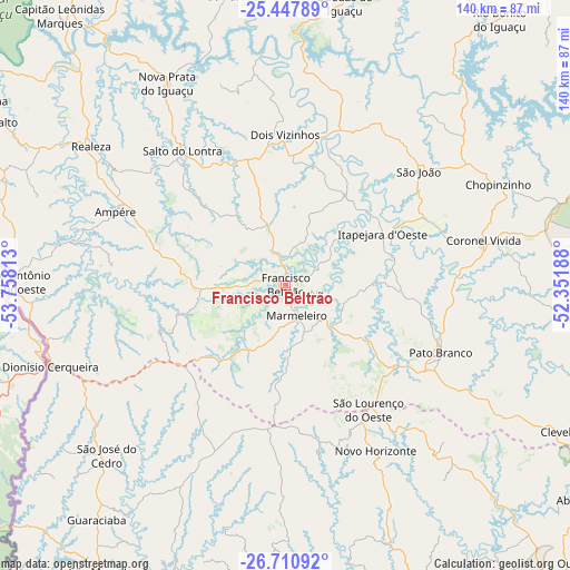
Francisco Beltrão GPS coordinates[2]
26° 4' 51.996" South, 53° 3' 18" West
| Map corner | latitude | longitude |
|---|---|---|
| Upper-left | -25.44789°, | -53.75813° |
| Center: | -26.08111°, | -53.055° |
| Lower-right: | -26.71092°, | -52.35188° |
| Map W x H: | 140.4×140.4 km | = 87.2×87.2mi |
| max Lat: | 2.81972° ⇑89.6% North |
| Francisco Beltrão: | -26.08111° |
| min Lat: | ⇓10.4% South -33.69111° |
| min Long | Francisco Beltr | max Long |
| -72.89583° | -53.055° | -32.41083° |
| W 9.5%⇐ | ⇒90.5% E |
Elevation
Elevation of Francisco Beltrão is 567 m = 1860 ft, and this is 186.1 m = 611 ft above average elevation for this country.
| Max E: |
1603 m = 5259 ft | 30.9% |
| Francisco Beltrão | 567 m 1860 ft | |
| Avg. | 380.9 m = 1250 ft | |
Min E: |
0 m = 0 ft | 69.1% |
See also: Francisco Beltrão elevation on elevation.city.
Geographical zone
Francisco Beltrão is located in South temperate zone (between Tropic of Capricorn and the Antarctic Circle). Distance of this Southern Tropic circle is 294 km =182.7 mi to North.| Distance of | km | miles | from Francisco Beltrão |
|---|---|---|---|
| Equator | 2899.9 | 1801.9 | to North |
| Tropic Capricorn | 294 | 182.7 | to North |
| Antarctic Circle | 4501.2 | 2796.9 | to South |
| South Pole | 7107.1 | 4416.1 | to South |


Nearby cities:
15 places around Francisco Beltrão: (largest is in red/bold)
• Ampére
45.7 km =28.4 mi,  293°
293°
• Cascavel
131.4 km =81.6 mi,  342°
342°
• Chapecó
120.9 km =75.1 mi,  158°
158°
• Chopinzinho
58.8 km =36.5 mi,  64°
64°
• Clevelândia
68 km =42.3 mi,  120°
120°
• Coronel Vivida
50 km =31.1 mi,  76°
76°
• Dois Vizinhos
38.6 km =24 mi,  359°
359°
• Guaraniaçu
110.4 km =68.6 mi,  9°
9°
• Laranjeiras do Sul
98.5 km =61.2 mi,  40°
40°
• Palmas
115.2 km =71.6 mi,  112°
112°
• Pato Branco
41.7 km =25.9 mi, 113°
• Realeza
59 km =36.7 mi,  306°
306°
• Santo Antônio do Sudoeste
66.9 km =41.6 mi,  270°
270°
• São Lourenço do Oeste
37 km =23 mi,  146°
146°
• Xanxerê
109.7 km =68.2 mi,  143°
143°
Sources, notices
• [Note1] Compared only with cities in Brazil existing in our database
• [Src1] Map data: © OpenStreetMap contributors (CC-BY-SA)
• [Src2] Other city data from geonames.org with taken over terms of usage.
• [Src3] Geographical zone / Annual Mean Temperature by Robert A. Rohde @ Wikipedia
