Gaspar geodata
Gaspar (Santa Catarina) is a populated place; located in Brazil in America/Sao_Paulo (GMT-3) time zone. With population of 33,658 people, there are 613 cities with bigger population in this country. Compared to other cities in Brazil, 91.2% of cities are located further ↑North; 71.2% of cities are located further →East and 93.2% of cities have higher elevation than Gaspar. Note1


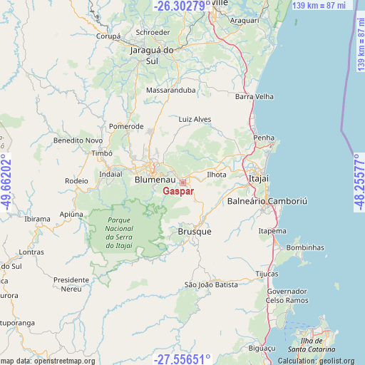
Gaspar GPS coordinates[2]
26° 55' 53.004" South, 48° 57' 32.004" West
| Map corner | latitude | longitude |
|---|---|---|
| Upper-left | -26.30279°, | -49.66202° |
| Center: | -26.93139°, | -48.95889° |
| Lower-right: | -27.55651°, | -48.25577° |
| Map W x H: | 139.4×139.4 km | = 86.6×86.6mi |
| max Lat: | 2.81972° ⇑91.2% North |
| Gaspar: | -26.93139° |
| min Lat: | ⇓8.8% South -33.69111° |
| min Long | Gaspar | max Long |
| -72.89583° | -48.95889° | -32.41083° |
| W 28.8%⇐ | ⇒71.2% E |
Elevation
Elevation of Gaspar is 12 m = 39 ft, and this is 368.9 m = 1210 ft below average elevation for this country.
| Max E: |
1603 m = 5259 ft | 93.2% |
| Avg. | 380.9 m = 1250 ft | |
| Gaspar | 12 m = 39 ft | |
Min E: |
0 m = 0 ft | 6.8% |
See also: Brazil elevation on elevation.city.
Geographical zone
Gaspar is located in South temperate zone (between Tropic of Capricorn and the Antarctic Circle). Distance of this Southern Tropic circle is 388.6 km =241.5 mi to North.| Distance of | km | miles | from Gaspar |
|---|---|---|---|
| Equator | 2994.5 | 1860.7 | to North |
| Tropic Capricorn | 388.6 | 241.5 | to North |
| Antarctic Circle | 4406.7 | 2738.2 | to South |
| South Pole | 7012.6 | 4357.4 | to South |


Nearby cities:
15 places around Gaspar: (largest is in red/bold)
• Balneário Camboriú
32.8 km =20.4 mi,  101°
101°
• Barra Velha
43 km =26.7 mi,  39°
39°
• Blumenau
10.7 km =6.6 mi,  277°
277°
• Brusque
19.1 km =11.9 mi,  166°
166°
• Indaial
27.3 km =17 mi, 277°
• Itajaí
29.6 km =18.4 mi,  84°
84°
• Itapema
38.7 km =24 mi,  117°
117°
• Navegantes
30.4 km =18.9 mi, 83°
• Penha
35.9 km =22.3 mi,  59°
59°
• Pomerode
30.3 km =18.8 mi,  314°
314°
• Residencia Moacir PU5BHV
40.4 km =25.1 mi,  273°
273°
• Rodeio
40.4 km =25.1 mi, 271°
• São João Batista
39.8 km =24.7 mi,  164°
164°
• Tijucas
47.2 km =29.3 mi,  136°
136°
• Timbó
33.3 km =20.7 mi,  291°
291°
Sources, notices
• [Note1] Compared only with cities in Brazil existing in our database
• [Src1] Map data: © OpenStreetMap contributors (CC-BY-SA)
• [Src2] Other city data from geonames.org with taken over terms of usage.
• [Src3] Geographical zone / Annual Mean Temperature by Robert A. Rohde @ Wikipedia
