Ponte Nova geodata
Ponte Nova (Minas Gerais) is a populated place; located in Brazil in America/Sao_Paulo (GMT-3) time zone. With population of 48,187 people, there are 444 cities with bigger population in this country. Compared to other cities in Brazil, 59.4% of cities are located further ↑North; 60.9% of cities are located further ←West and 56.6% of cities have lower elevation than Ponte Nova. Note1


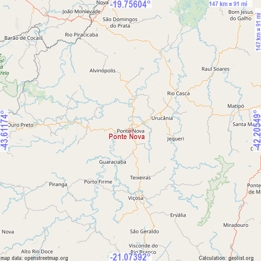
Ponte Nova GPS coordinates[2]
20° 24' 59.004" South, 42° 54' 30.996" West
| Map corner | latitude | longitude |
|---|---|---|
| Upper-left | -19.75604°, | -43.61174° |
| Center: | -20.41639°, | -42.90861° |
| Lower-right: | -21.07392°, | -42.20549° |
| Map W x H: | 146.5×146.5 km | = 91×91mi |
| max Lat: | 2.81972° ⇑59.4% North |
| Ponte Nova: | -20.41639° |
| min Lat: | ⇓40.6% South -33.69111° |
| min Long | Ponte Nova | max Long |
| -72.89583° | -42.90861° | -32.41083° |
| W 60.9%⇐ | ⇒39.1% E |
Elevation
Elevation of Ponte Nova is 438 m = 1437 ft, and this is 57.1 m = 187 ft above average elevation for this country.
| Max E: |
1603 m = 5259 ft | 43.4% |
| Ponte Nova | 438 m 1437 ft | |
| Avg. | 380.9 m = 1250 ft | |
Min E: |
0 m = 0 ft | 56.6% |
See also: Ponte Nova elevation on elevation.city.
Geographical zone
Ponte Nova is located in South Torrid zone (between Equator and Tropic of Capricorn). Distance of this Southern Tropic circle is 335.8 km =208.7 mi to South.| Distance of | km | miles | from Ponte Nova |
|---|---|---|---|
| Equator | 2270.1 | 1410.6 | to North |
| Tropic Capricorn | 335.8 | 208.7 | to South |
| Antarctic Circle | 5131.1 | 3188.3 | to South |
| South Pole | 7737 | 4807.5 | to South |


Nearby cities:
15 places around Ponte Nova: (largest is in red/bold)
• Alvinópolis
37.4 km =23.2 mi,  336°
336°
• Barão de Cocais
79.9 km =49.6 mi,  310°
310°
• João Monlevade
72.9 km =45.3 mi, 337°
• Mariana
53.1 km =33 mi,  274°
274°
• Matipó
61 km =37.9 mi,  76°
76°
• Nova Era
75.3 km =46.8 mi,  349°
349°
• Ouro Branco
82.8 km =51.4 mi,  261°
261°
• Ouro Preto
62.2 km =38.6 mi, 272°
• Rio Casca
34.2 km =21.3 mi,  51°
51°
• Rio Piracicaba
60.9 km =37.8 mi,  332°
332°
• São Domingos do Prata
61.6 km =38.3 mi, 354°
• Tocantins
85.1 km =52.9 mi,  187°
187°
• Ubá
78.3 km =48.7 mi,  182°
182°
• Visconde do Rio Branco
66.4 km =41.3 mi,  173°
173°
• Viçosa
37.6 km =23.4 mi, 175°
Sources, notices
• [Note1] Compared only with cities in Brazil existing in our database
• [Src1] Map data: © OpenStreetMap contributors (CC-BY-SA)
• [Src2] Other city data from geonames.org with taken over terms of usage.
• [Src3] Geographical zone / Annual Mean Temperature by Robert A. Rohde @ Wikipedia
