Ubá geodata
Ubá (Minas Gerais) is a populated place; located in Brazil in America/Sao_Paulo (GMT-3) time zone. With population of 97,828 people, there are 238 cities with bigger population in this country. Compared to other cities in Brazil, 63.8% of cities are located further ↑North; 60.7% of cities are located further ←West and 50.9% of cities have higher elevation than Ubá. Note1


Ubá GPS coordinates[2]
21° 7' 12" South, 42° 56' 34.008" West
| Map corner | latitude | longitude |
|---|---|---|
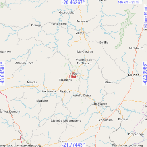
| Upper-left | -20.46267°, | -43.64591° |
| Center: | -21.12°, | -42.94278° |
| Lower-right: | -21.77443°, | -42.23966° |
| Map W x H: | 145.9×145.9 km | = 90.7×90.7mi |
| max Lat: | 2.81972° ⇑63.8% North |
| Ubá: | -21.12° |
| min Lat: | ⇓36.2% South -33.69111° |
| min Long | Ubá | max Long |
| -72.89583° | -42.94278° | -32.41083° |
| W 60.7%⇐ | ⇒39.3% E |
Elevation
Elevation of Ubá is 343 m = 1125 ft, and this is 37.9 m = 124 ft below average elevation for this country.
| Max E: |
1603 m = 5259 ft | 50.9% |
| Avg. | 380.9 m = 1250 ft | |
| Ubá | 343 m = 1125 ft | |
Min E: |
0 m = 0 ft | 49.1% |
See also: Ubá elevation on elevation.city.
Geographical zone
Ubá is located in South Torrid zone (between Equator and Tropic of Capricorn). Distance of this Southern Tropic circle is 257.6 km =160.1 mi to South.| Distance of | km | miles | from Ubá |
|---|---|---|---|
| Equator | 2348.3 | 1459.2 | to North |
| Tropic Capricorn | 257.6 | 160.1 | to South |
| Antarctic Circle | 5052.9 | 3139.7 | to South |
| South Pole | 7658.7 | 4758.9 | to South |


Nearby cities:
15 places around Ubá: (largest is in red/bold)
• Astolfo Dutra
23.3 km =14.5 mi,  158°
158°
• Bicas
68.4 km =42.5 mi,  190°
190°
• Cataguases
39.3 km =24.4 mi,  139°
139°
• Leopoldina
55.3 km =34.4 mi,  145°
145°
• Miraí
35.1 km =21.8 mi,  103°
103°
• Muriaé
59.8 km =37.2 mi,  91°
91°
• Ponte Nova
78.3 km =48.7 mi,  2°
2°
• Recreio
66.6 km =41.4 mi,  132°
132°
• Rio Novo
44 km =27.3 mi,  205°
205°
• Rio Pomba
29.9 km =18.6 mi,  234°
234°
• Santos Dumont
73.4 km =45.6 mi,  239°
239°
• São João Nepomuceno
47.2 km =29.3 mi, 188°
• Tocantins
9.9 km =6.2 mi, 231°
• Visconde do Rio Branco
16.2 km =10.1 mi,  41°
41°
• Viçosa
41.2 km =25.6 mi,  8°
8°
Sources, notices
• [Note1] Compared only with cities in Brazil existing in our database
• [Src1] Map data: © OpenStreetMap contributors (CC-BY-SA)
• [Src2] Other city data from geonames.org with taken over terms of usage.
• [Src3] Geographical zone / Annual Mean Temperature by Robert A. Rohde @ Wikipedia
