Matipó geodata
Matipó (Minas Gerais) is a populated place; located in Brazil in America/Sao_Paulo (GMT-3) time zone. With population of 12,996 people, there are 1368 cities with bigger population in this country. Compared to other cities in Brazil, 58.7% of cities are located further ↑North; 64.4% of cities are located further ←West and 74.5% of cities have lower elevation than Matipó. Note1


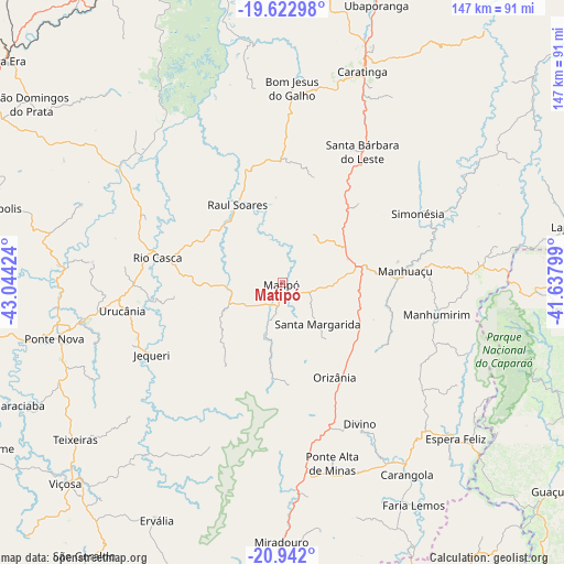
Matipó GPS coordinates[2]
20° 17' 2.004" South, 42° 20' 27.996" West
| Map corner | latitude | longitude |
|---|---|---|
| Upper-left | -19.62298°, | -43.04424° |
| Center: | -20.28389°, | -42.34111° |
| Lower-right: | -20.942°, | -41.63799° |
| Map W x H: | 146.7×146.7 km | = 91.2×91.2mi |
| max Lat: | 2.81972° ⇑58.7% North |
| Matipó: | -20.28389° |
| min Lat: | ⇓41.3% South -33.69111° |
| min Long | Matipó | max Long |
| -72.89583° | -42.34111° | -32.41083° |
| W 64.4%⇐ | ⇒35.6% E |
Elevation
Elevation of Matipó is 621 m = 2037 ft, and this is 240.1 m = 788 ft above average elevation for this country.
| Max E: |
1603 m = 5259 ft | 25.5% |
| Matipó | 621 m 2037 ft | |
| Avg. | 380.9 m = 1250 ft | |
Min E: |
0 m = 0 ft | 74.5% |
See also: Brazil elevation on elevation.city.
Geographical zone
Matipó is located in South Torrid zone (between Equator and Tropic of Capricorn). Distance of this Southern Tropic circle is 350.6 km =217.9 mi to South.| Distance of | km | miles | from Matipó |
|---|---|---|---|
| Equator | 2255.4 | 1401.4 | to North |
| Tropic Capricorn | 350.6 | 217.9 | to South |
| Antarctic Circle | 5145.8 | 3197.5 | to South |
| South Pole | 7751.7 | 4816.7 | to South |


Nearby cities:
15 places around Matipó: (largest is in red/bold)
• Alvinópolis
76.4 km =47.5 mi,  284°
284°
• Bom Jesus do Galho
50.7 km =31.5 mi,  2°
2°
• Carangola
59.6 km =37 mi,  146°
146°
• Caratinga
58.9 km =36.6 mi,  21°
21°
• Espera Feliz
60.8 km =37.8 mi,  132°
132°
• Irupi
73.3 km =45.5 mi,  95°
95°
• Iúna
84.3 km =52.4 mi,  94°
94°
• Lajinha
76.4 km =47.5 mi,  78°
78°
• Manhuaçu
32.2 km =20 mi, 84°
• Manhumirim
40.8 km =25.4 mi, 101°
• Ponte Nova
61 km =37.9 mi,  256°
256°
• Porciúncula
81.7 km =50.8 mi,  157°
157°
• Rio Casca
32.9 km =20.4 mi, 281°
• São Domingos do Prata
80.4 km =50 mi,  305°
305°
• Viçosa
76.8 km =47.7 mi,  227°
227°
Sources, notices
• [Note1] Compared only with cities in Brazil existing in our database
• [Src1] Map data: © OpenStreetMap contributors (CC-BY-SA)
• [Src2] Other city data from geonames.org with taken over terms of usage.
• [Src3] Geographical zone / Annual Mean Temperature by Robert A. Rohde @ Wikipedia
