Viçosa geodata
Viçosa (Minas Gerais) is a populated place; located in Brazil in America/Sao_Paulo (GMT-3) time zone. With population of 68,680 people, there are 330 cities with bigger population in this country. Compared to other cities in Brazil, 61.5% of cities are located further ↑North; 61.1% of cities are located further ←West and 77.3% of cities have lower elevation than Viçosa. Note1


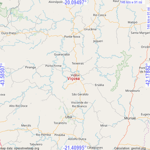
Viçosa GPS coordinates[2]
20° 45' 14.004" South, 42° 52' 54.984" West
| Map corner | latitude | longitude |
|---|---|---|
| Upper-left | -20.09497°, | -43.58507° |
| Center: | -20.75389°, | -42.88194° |
| Lower-right: | -21.40995°, | -42.17882° |
| Map W x H: | 146.2×146.2 km | = 90.8×90.8mi |
| max Lat: | 2.81972° ⇑61.5% North |
| Viçosa: | -20.75389° |
| min Lat: | ⇓38.5% South -33.69111° |
| min Long | Viçosa | max Long |
| -72.89583° | -42.88194° | -32.41083° |
| W 61.1%⇐ | ⇒38.9% E |
Elevation
Elevation of Viçosa is 656 m = 2152 ft, and this is 275.1 m = 903 ft above average elevation for this country.
| Max E: |
1603 m = 5259 ft | 22.7% |
| Viçosa | 656 m 2152 ft | |
| Avg. | 380.9 m = 1250 ft | |
Min E: |
0 m = 0 ft | 77.3% |
See also: Viçosa elevation on elevation.city.
Geographical zone
Viçosa is located in South Torrid zone (between Equator and Tropic of Capricorn). Distance of this Southern Tropic circle is 298.3 km =185.4 mi to South.| Distance of | km | miles | from Viçosa |
|---|---|---|---|
| Equator | 2307.6 | 1433.9 | to North |
| Tropic Capricorn | 298.3 | 185.4 | to South |
| Antarctic Circle | 5093.6 | 3165 | to South |
| South Pole | 7699.4 | 4784.2 | to South |


Nearby cities:
15 places around Viçosa: (largest is in red/bold)
• Alvinópolis
74 km =46 mi,  346°
346°
• Astolfo Dutra
62.5 km =38.8 mi,  178°
178°
• Cataguases
73.2 km =45.5 mi,  164°
164°
• Mariana
69.6 km =43.2 mi,  306°
306°
• Matipó
76.8 km =47.7 mi,  47°
47°
• Miraí
56.4 km =35 mi,  150°
150°
• Muriaé
68 km =42.3 mi,  128°
128°
• Ouro Preto
76.2 km =47.3 mi,  301°
301°
• Ponte Nova
37.6 km =23.4 mi,  355°
355°
• Rio Casca
63.4 km =39.4 mi,  22°
22°
• Rio Novo
84.3 km =52.4 mi,  197°
197°
• Rio Pomba
65.6 km =40.8 mi,  208°
208°
• Tocantins
48.9 km =30.4 mi, 196°
• Ubá
41.2 km =25.6 mi,  188°
188°
• Visconde do Rio Branco
28.8 km =17.9 mi,  171°
171°
Sources, notices
• [Note1] Compared only with cities in Brazil existing in our database
• [Src1] Map data: © OpenStreetMap contributors (CC-BY-SA)
• [Src2] Other city data from geonames.org with taken over terms of usage.
• [Src3] Geographical zone / Annual Mean Temperature by Robert A. Rohde @ Wikipedia
