Ouro Preto geodata
Ouro Preto (Minas Gerais) is a populated place; located in Brazil in America/Sao_Paulo (GMT-3) time zone. With population of 63,678 people, there are 349 cities with bigger population in this country. Compared to other cities in Brazil, 59.3% of cities are located further ↑North; 58% of cities are located further ←West and 99.7% of cities have lower elevation than Ouro Preto. Note1


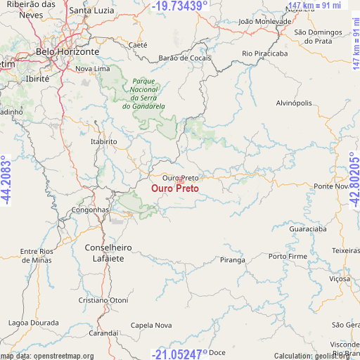
Ouro Preto GPS coordinates[2]
20° 23' 41.424" South, 43° 30' 18.612" West
| Map corner | latitude | longitude |
|---|---|---|
| Upper-left | -19.73439°, | -44.2083° |
| Center: | -20.39484°, | -43.50517° |
| Lower-right: | -21.05247°, | -42.80205° |
| Map W x H: | 146.6×146.6 km | = 91.1×91.1mi |
| max Lat: | 2.81972° ⇑59.3% North |
| Ouro Preto: | -20.39484° |
| min Lat: | ⇓40.7% South -33.69111° |
| min Long | Ouro Preto | max Long |
| -72.89583° | -43.50517° | -32.41083° |
| W 58%⇐ | ⇒42% E |
Elevation
Elevation of Ouro Preto is 1201 m = 3940 ft, and this is 820.1 m = 2691 ft above average elevation for this country.
| Max E: |
1603 m = 5259 ft | 0.3% |
| Ouro Preto | 1201 m 3940 ft | |
| Avg. | 380.9 m = 1250 ft | |
Min E: |
0 m = 0 ft | 99.7% |
See also: Ouro Preto elevation on elevation.city.
Geographical zone
Ouro Preto is located in South Torrid zone (between Equator and Tropic of Capricorn). Distance of this Southern Tropic circle is 338.2 km =210.1 mi to South.| Distance of | km | miles | from Ouro Preto |
|---|---|---|---|
| Equator | 2267.7 | 1409.1 | to North |
| Tropic Capricorn | 338.2 | 210.1 | to South |
| Antarctic Circle | 5133.5 | 3189.8 | to South |
| South Pole | 7739.4 | 4809 | to South |


Nearby cities:
15 places around Ouro Preto: (largest is in red/bold)
• Alvinópolis
57.4 km =35.7 mi,  56°
56°
• Barão de Cocais
50 km =31.1 mi,  2°
2°
• Belo Horizonte
69.4 km =43.1 mi,  319°
319°
• Caeté
59.8 km =37.2 mi,  343°
343°
• Carandaí
69.6 km =43.2 mi,  206°
206°
• Congonhas
38.8 km =24.1 mi,  251°
251°
• Conselheiro Lafaiete
41.6 km =25.8 mi,  224°
224°
• Ibirité
71.1 km =44.2 mi,  305°
305°
• Itabirito
34.7 km =21.6 mi,  296°
296°
• Mariana
9.5 km =5.9 mi,  78°
78°
• Nova Lima
57.8 km =35.9 mi, 321°
• Ouro Branco
24.4 km =15.2 mi,  234°
234°
• Ponte Nova
62.2 km =38.6 mi,  92°
92°
• Raposos
56.9 km =35.4 mi,  326°
326°
• Rio Piracicaba
62.2 km =38.6 mi,  33°
33°
Sources, notices
• [Note1] Compared only with cities in Brazil existing in our database
• [Src1] Map data: © OpenStreetMap contributors (CC-BY-SA)
• [Src2] Other city data from geonames.org with taken over terms of usage.
• [Src3] Geographical zone / Annual Mean Temperature by Robert A. Rohde @ Wikipedia
