São Carlos geodata
São Carlos (São Paulo) is a populated place; located in Brazil in America/Sao_Paulo (GMT-3) time zone. With population of 205,035 people, there are 111 cities with bigger population in this country. Compared to other cities in Brazil, 70.2% of cities are located further ↑North; 64% of cities are located further →East and 91.5% of cities have lower elevation than São Carlos. Note1


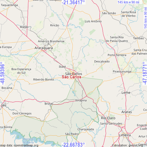
São Carlos GPS coordinates[2]
22° 1' 3" South, 47° 53' 26.988" West
| Map corner | latitude | longitude |
|---|---|---|
| Upper-left | -21.36417°, | -48.59396° |
| Center: | -22.0175°, | -47.89083° |
| Lower-right: | -22.66783°, | -47.18771° |
| Map W x H: | 145×145 km | = 90.1×90.1mi |
| max Lat: | 2.81972° ⇑70.2% North |
| São Carlos: | -22.0175° |
| min Lat: | ⇓29.8% South -33.69111° |
| min Long | São Carlos | max Long |
| -72.89583° | -47.89083° | -32.41083° |
| W 36%⇐ | ⇒64% E |
Elevation
Elevation of São Carlos is 838 m = 2749 ft, and this is 457.1 m = 1500 ft above average elevation for this country.
| Max E: |
1603 m = 5259 ft | 8.5% |
| São Carlos | 838 m 2749 ft | |
| Avg. | 380.9 m = 1250 ft | |
Min E: |
0 m = 0 ft | 91.5% |
See also: São Carlos elevation on elevation.city.
Geographical zone
São Carlos is located in South Torrid zone (between Equator and Tropic of Capricorn). Distance of this Southern Tropic circle is 157.8 km =98.1 mi to South.| Distance of | km | miles | from São Carlos |
|---|---|---|---|
| Equator | 2448.1 | 1521.2 | to North |
| Tropic Capricorn | 157.8 | 98.1 | to South |
| Antarctic Circle | 4953.1 | 3077.7 | to South |
| South Pole | 7558.9 | 4696.9 | to South |


Nearby cities:
15 places around São Carlos: (largest is in red/bold)
• Américo Brasiliense
39.2 km =24.4 mi,  326°
326°
• Araraquara
38.4 km =23.9 mi,  310°
310°
• Boa Esperança do Sul
51.6 km =32.1 mi,  273°
273°
• Brotas
38.3 km =23.8 mi,  219°
219°
• Charqueada
55.9 km =34.7 mi,  168°
168°
• Descalvado
30.7 km =19.1 mi,  65°
65°
• Ibaté
13 km =8.1 mi,  302°
302°
• Itirapina
27.1 km =16.8 mi, 165°
• Leme
54.8 km =34.1 mi,  109°
109°
• Pirassununga
48 km =29.8 mi,  87°
87°
• Porto Ferreira
46.2 km =28.7 mi, 66°
• Ribeirão Bonito
29.9 km =18.6 mi,  259°
259°
• Rio Claro
55.4 km =34.4 mi,  142°
142°
• Santa Rita do Passa Quatro
54.6 km =33.9 mi,  51°
51°
• São Pedro
59.1 km =36.7 mi,  182°
182°
Sources, notices
• [Note1] Compared only with cities in Brazil existing in our database
• [Src1] Map data: © OpenStreetMap contributors (CC-BY-SA)
• [Src2] Other city data from geonames.org with taken over terms of usage.
• [Src3] Geographical zone / Annual Mean Temperature by Robert A. Rohde @ Wikipedia
