Conselheiro Lafaiete geodata
Conselheiro Lafaiete (Minas Gerais) is a populated place; located in Brazil in America/Sao_Paulo (GMT-3) time zone. With population of 111,596 people, there are 200 cities with bigger population in this country. Compared to other cities in Brazil, 60.9% of cities are located further ↑North; 57.1% of cities are located further ←West and 98.2% of cities have lower elevation than Conselheiro Lafaiete. Note1


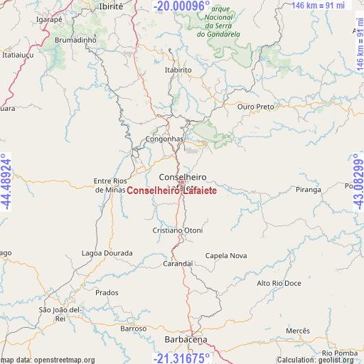
Conselheiro Lafaiete GPS coordinates[2]
20° 39' 37.008" South, 43° 47' 9.996" West
| Map corner | latitude | longitude |
|---|---|---|
| Upper-left | -20.00096°, | -44.48924° |
| Center: | -20.66028°, | -43.78611° |
| Lower-right: | -21.31675°, | -43.08299° |
| Map W x H: | 146.3×146.3 km | = 90.9×90.9mi |
| max Lat: | 2.81972° ⇑60.9% North |
| Conselheiro Lafaiete: | -20.66028° |
| min Lat: | ⇓39.1% South -33.69111° |
| min Long | Conselheiro Laf | max Long |
| -72.89583° | -43.78611° | -32.41083° |
| W 57.1%⇐ | ⇒42.9% E |
Elevation
Elevation of Conselheiro Lafaiete is 998 m = 3274 ft, and this is 617.1 m = 2025 ft above average elevation for this country.
| Max E: |
1603 m = 5259 ft | 1.8% |
| Conselheiro Lafaiete | 998 m 3274 ft | |
| Avg. | 380.9 m = 1250 ft | |
Min E: |
0 m = 0 ft | 98.2% |
See also: Conselheiro Lafaiete elevation on elevation.city.
Geographical zone
Conselheiro Lafaiete is located in South Torrid zone (between Equator and Tropic of Capricorn). Distance of this Southern Tropic circle is 308.7 km =191.8 mi to South.| Distance of | km | miles | from Conselheiro Lafaiete |
|---|---|---|---|
| Equator | 2297.2 | 1427.4 | to North |
| Tropic Capricorn | 308.7 | 191.8 | to South |
| Antarctic Circle | 5104 | 3171.5 | to South |
| South Pole | 7709.9 | 4790.7 | to South |


Nearby cities:
15 places around Conselheiro Lafaiete: (largest is in red/bold)
• Barbacena
62.9 km =39.1 mi,  178°
178°
• Barroso
61.8 km =38.4 mi,  198°
198°
• Brumadinho
71.8 km =44.6 mi,  323°
323°
• Carandaí
32.7 km =20.3 mi, 183°
• Congonhas
18.8 km =11.7 mi,  336°
336°
• Ibirité
76.5 km =47.5 mi, 338°
• Itabirito
45.3 km =28.1 mi,  357°
357°
• Mariana
49.7 km =30.9 mi,  50°
50°
• Nova Lima
75.3 km =46.8 mi, 355°
• Ouro Branco
17.9 km =11.1 mi,  31°
31°
• Ouro Preto
41.6 km =25.8 mi,  44°
44°
• Raposos
77.1 km =47.9 mi, 358°
• Sarzedo
78.9 km =49 mi,  331°
331°
• São João del Rei
72.3 km =44.9 mi,  223°
223°
• Tiradentes
64.5 km =40.1 mi, 219°
Sources, notices
• [Note1] Compared only with cities in Brazil existing in our database
• [Src1] Map data: © OpenStreetMap contributors (CC-BY-SA)
• [Src2] Other city data from geonames.org with taken over terms of usage.
• [Src3] Geographical zone / Annual Mean Temperature by Robert A. Rohde @ Wikipedia
