Carandaí geodata
Carandaí (Minas Gerais) is a populated place; located in Brazil in America/Sao_Paulo (GMT-3) time zone. With population of 16,657 people, there are 1113 cities with bigger population in this country. Compared to other cities in Brazil, 62.8% of cities are located further ↑North; 56.9% of cities are located further ←West and 99.5% of cities have lower elevation than Carandaí. Note1


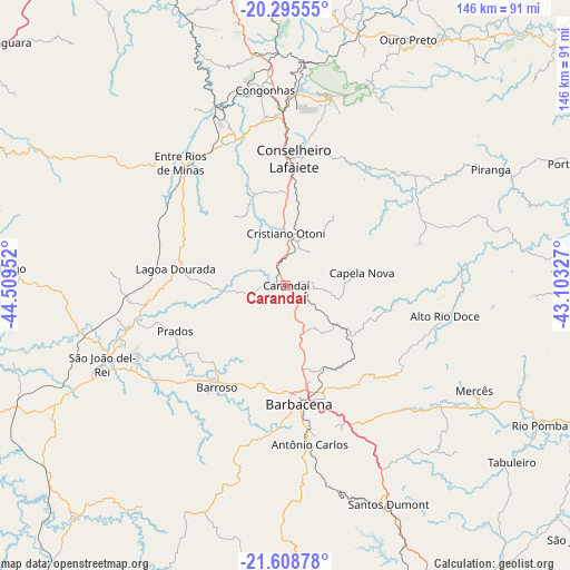
Carandaí GPS coordinates[2]
20° 57' 12.996" South, 43° 48' 23.004" West
| Map corner | latitude | longitude |
|---|---|---|
| Upper-left | -20.29555°, | -44.50952° |
| Center: | -20.95361°, | -43.80639° |
| Lower-right: | -21.60878°, | -43.10327° |
| Map W x H: | 146×146 km | = 90.7×90.7mi |
| max Lat: | 2.81972° ⇑62.8% North |
| Carandaí: | -20.95361° |
| min Lat: | ⇓37.2% South -33.69111° |
| min Long | Carandaí | max Long |
| -72.89583° | -43.80639° | -32.41083° |
| W 56.9%⇐ | ⇒43.1% E |
Elevation
Elevation of Carandaí is 1096 m = 3596 ft, and this is 715.1 m = 2346 ft above average elevation for this country.
| Max E: |
1603 m = 5259 ft | 0.5% |
| Carandaí | 1096 m 3596 ft | |
| Avg. | 380.9 m = 1250 ft | |
Min E: |
0 m = 0 ft | 99.5% |
See also: Brazil elevation on elevation.city.
Geographical zone
Carandaí is located in South Torrid zone (between Equator and Tropic of Capricorn). Distance of this Southern Tropic circle is 276.1 km =171.6 mi to South.| Distance of | km | miles | from Carandaí |
|---|---|---|---|
| Equator | 2329.8 | 1447.7 | to North |
| Tropic Capricorn | 276.1 | 171.6 | to South |
| Antarctic Circle | 5071.4 | 3151.2 | to South |
| South Pole | 7677.2 | 4770.4 | to South |


Nearby cities:
15 places around Carandaí: (largest is in red/bold)
• Barbacena
30.5 km =19 mi,  173°
173°
• Barroso
31.3 km =19.4 mi,  214°
214°
• Congonhas
50.1 km =31.1 mi,  353°
353°
• Conselheiro Lafaiete
32.7 km =20.3 mi,  3°
3°
• Itabirito
77.9 km =48.4 mi, 0°
• Mariana
75.8 km =47.1 mi,  32°
32°
• Ouro Branco
49.2 km =30.6 mi,  13°
13°
• Ouro Preto
69.6 km =43.2 mi, 26°
• Rio Novo
91.4 km =56.8 mi,  129°
129°
• Rio Pomba
74.2 km =46.1 mi,  118°
118°
• Santos Dumont
61.8 km =38.4 mi,  154°
154°
• São João del Rei
51.4 km =31.9 mi,  246°
246°
• Tiradentes
42.3 km =26.3 mi, 245°
• Tocantins
85.4 km =53.1 mi,  106°
106°
• Ubá
91.5 km =56.9 mi,  101°
101°
Sources, notices
• [Note1] Compared only with cities in Brazil existing in our database
• [Src1] Map data: © OpenStreetMap contributors (CC-BY-SA)
• [Src2] Other city data from geonames.org with taken over terms of usage.
• [Src3] Geographical zone / Annual Mean Temperature by Robert A. Rohde @ Wikipedia
