Matão geodata
Matão (São Paulo) is a populated place; located in Brazil in America/Sao_Paulo (GMT-3) time zone. With population of 72,468 people, there are 311 cities with bigger population in this country. Compared to other cities in Brazil, 67.3% of cities are located further ↑North; 66.3% of cities are located further →East and 70.1% of cities have lower elevation than Matão. Note1


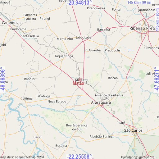
Matão GPS coordinates[2]
21° 36' 11.988" South, 48° 21' 56.988" West
| Map corner | latitude | longitude |
|---|---|---|
| Upper-left | -20.94813°, | -49.06896° |
| Center: | -21.60333°, | -48.36583° |
| Lower-right: | -22.25558°, | -47.66271° |
| Map W x H: | 145.4×145.4 km | = 90.3×90.3mi |
| max Lat: | 2.81972° ⇑67.3% North |
| Matão: | -21.60333° |
| min Lat: | ⇓32.7% South -33.69111° |
| min Long | Matão | max Long |
| -72.89583° | -48.36583° | -32.41083° |
| W 33.7%⇐ | ⇒66.3% E |
Elevation
Elevation of Matão is 574 m = 1883 ft, and this is 193.1 m = 634 ft above average elevation for this country.
| Max E: |
1603 m = 5259 ft | 29.9% |
| Matão | 574 m 1883 ft | |
| Avg. | 380.9 m = 1250 ft | |
Min E: |
0 m = 0 ft | 70.1% |
See also: Matão elevation on elevation.city.
Geographical zone
Matão is located in South Torrid zone (between Equator and Tropic of Capricorn). Distance of this Southern Tropic circle is 203.9 km =126.7 mi to South.| Distance of | km | miles | from Matão |
|---|---|---|---|
| Equator | 2402.1 | 1492.6 | to North |
| Tropic Capricorn | 203.9 | 126.7 | to South |
| Antarctic Circle | 4999.1 | 3106.3 | to South |
| South Pole | 7605 | 4725.5 | to South |


Nearby cities:
15 places around Matão: (largest is in red/bold)
• Américo Brasiliense
30.4 km =18.9 mi,  116°
116°
• Araraquara
28.9 km =18 mi,  137°
137°
• Barrinha
50.1 km =31.1 mi,  24°
24°
• Boa Esperança do Sul
43.3 km =26.9 mi,  183°
183°
• Guariba
30.6 km =19 mi,  27°
27°
• Ibaté
54.6 km =33.9 mi, 135°
• Ibitinga
50.8 km =31.6 mi,  250°
250°
• Itápolis
46.2 km =28.7 mi,  271°
271°
• Jaboticabal
39 km =24.2 mi,  6°
6°
• Monte Alto
40.4 km =25.1 mi,  340°
340°
• Pradópolis
41.2 km =25.6 mi,  48°
48°
• Ribeirão Bonito
55.1 km =34.2 mi,  159°
159°
• Santa Adélia
60.5 km =37.6 mi,  311°
311°
• Tabatinga
35.5 km =22.1 mi, 249°
• Taquaritinga
26.2 km =16.3 mi,  326°
326°
Sources, notices
• [Note1] Compared only with cities in Brazil existing in our database
• [Src1] Map data: © OpenStreetMap contributors (CC-BY-SA)
• [Src2] Other city data from geonames.org with taken over terms of usage.
• [Src3] Geographical zone / Annual Mean Temperature by Robert A. Rohde @ Wikipedia
