Ibitinga geodata
Ibitinga (São Paulo) is a populated place; located in Brazil in America/Sao_Paulo (GMT-3) time zone. With population of 49,074 people, there are 436 cities with bigger population in this country. Compared to other cities in Brazil, 68.4% of cities are located further ↑North; 70.4% of cities are located further →East and 62.3% of cities have lower elevation than Ibitinga. Note1


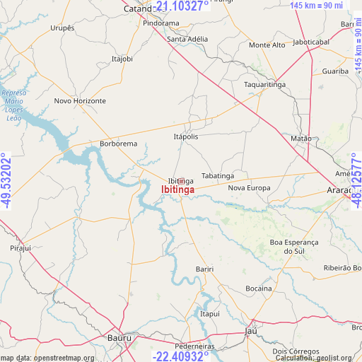
Ibitinga GPS coordinates[2]
21° 45' 28.008" South, 48° 49' 44.004" West
| Map corner | latitude | longitude |
|---|---|---|
| Upper-left | -21.10327°, | -49.53202° |
| Center: | -21.75778°, | -48.82889° |
| Lower-right: | -22.40932°, | -48.12577° |
| Map W x H: | 145.2×145.2 km | = 90.2×90.2mi |
| max Lat: | 2.81972° ⇑68.4% North |
| Ibitinga: | -21.75778° |
| min Lat: | ⇓31.6% South -33.69111° |
| min Long | Ibitinga | max Long |
| -72.89583° | -48.82889° | -32.41083° |
| W 29.6%⇐ | ⇒70.4% E |
Elevation
Elevation of Ibitinga is 500 m = 1640 ft, and this is 119.1 m = 391 ft above average elevation for this country.
| Max E: |
1603 m = 5259 ft | 37.7% |
| Ibitinga | 500 m 1640 ft | |
| Avg. | 380.9 m = 1250 ft | |
Min E: |
0 m = 0 ft | 62.3% |
See also: Ibitinga elevation on elevation.city.
Geographical zone
Ibitinga is located in South Torrid zone (between Equator and Tropic of Capricorn). Distance of this Southern Tropic circle is 186.7 km =116 mi to South.| Distance of | km | miles | from Ibitinga |
|---|---|---|---|
| Equator | 2419.2 | 1503.2 | to North |
| Tropic Capricorn | 186.7 | 116 | to South |
| Antarctic Circle | 4981.9 | 3095.6 | to South |
| South Pole | 7587.8 | 4714.8 | to South |


Nearby cities:
15 places around Ibitinga: (largest is in red/bold)
• Bariri
36.4 km =22.6 mi,  165°
165°
• Boa Esperança do Sul
52.2 km =32.4 mi,  120°
120°
• Boracéia
48.7 km =30.3 mi, 173°
• Borborema
29.6 km =18.4 mi,  301°
301°
• Itajobi
54.2 km =33.7 mi,  334°
334°
• Itapuí
54.1 km =33.6 mi, 167°
• Itápolis
18.1 km =11.2 mi,  5°
5°
• Jaú
66.1 km =41.1 mi,  154°
154°
• Matão
50.8 km =31.6 mi,  70°
70°
• Monte Alto
65.1 km =40.5 mi,  31°
31°
• Novo Horizonte
51.8 km =32.2 mi,  308°
308°
• Pindorama
64.1 km =39.8 mi,  352°
352°
• Santa Adélia
57.3 km =35.6 mi,  2°
2°
• Tabatinga
15.3 km =9.5 mi, 72°
• Taquaritinga
51.5 km =32 mi,  40°
40°
Sources, notices
• [Note1] Compared only with cities in Brazil existing in our database
• [Src1] Map data: © OpenStreetMap contributors (CC-BY-SA)
• [Src2] Other city data from geonames.org with taken over terms of usage.
• [Src3] Geographical zone / Annual Mean Temperature by Robert A. Rohde @ Wikipedia
