Araraquara geodata
Araraquara (São Paulo) is a populated place; located in Brazil in America/Sao_Paulo (GMT-3) time zone. With population of 168,468 people, there are 136 cities with bigger population in this country. Compared to other cities in Brazil, 68.6% of cities are located further ↑North; 65.5% of cities are located further →East and 78.9% of cities have lower elevation than Araraquara. Note1


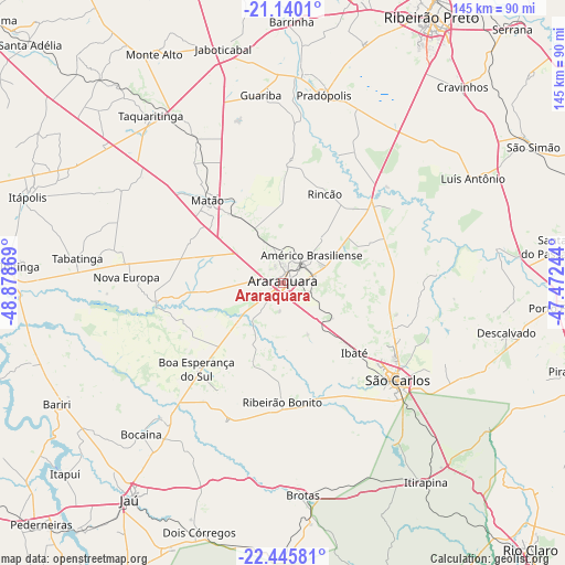
Araraquara GPS coordinates[2]
21° 47' 39.984" South, 48° 10' 32.016" West
| Map corner | latitude | longitude |
|---|---|---|
| Upper-left | -21.1401°, | -48.87869° |
| Center: | -21.79444°, | -48.17556° |
| Lower-right: | -22.44581°, | -47.47244° |
| Map W x H: | 145.2×145.2 km | = 90.2×90.2mi |
| max Lat: | 2.81972° ⇑68.6% North |
| Araraquara: | -21.79444° |
| min Lat: | ⇓31.4% South -33.69111° |
| min Long | Araraquara | max Long |
| -72.89583° | -48.17556° | -32.41083° |
| W 34.5%⇐ | ⇒65.5% E |
Elevation
Elevation of Araraquara is 677 m = 2221 ft, and this is 296.1 m = 971 ft above average elevation for this country.
| Max E: |
1603 m = 5259 ft | 21.1% |
| Araraquara | 677 m 2221 ft | |
| Avg. | 380.9 m = 1250 ft | |
Min E: |
0 m = 0 ft | 78.9% |
See also: Araraquara elevation on elevation.city.
Geographical zone
Araraquara is located in South Torrid zone (between Equator and Tropic of Capricorn). Distance of this Southern Tropic circle is 182.6 km =113.5 mi to South.| Distance of | km | miles | from Araraquara |
|---|---|---|---|
| Equator | 2423.3 | 1505.8 | to North |
| Tropic Capricorn | 182.6 | 113.5 | to South |
| Antarctic Circle | 4977.9 | 3093.1 | to South |
| South Pole | 7583.7 | 4712.3 | to South |


Nearby cities:
15 places around Araraquara: (largest is in red/bold)
• Américo Brasiliense
10.9 km =6.8 mi,  44°
44°
• Bariri
66 km =41 mi,  241°
241°
• Boa Esperança do Sul
31.3 km =19.4 mi,  225°
225°
• Brotas
54.7 km =34 mi,  174°
174°
• Descalvado
58.7 km =36.5 mi,  101°
101°
• Guariba
48.6 km =30.2 mi,  353°
353°
• Ibaté
25.7 km =16 mi,  133°
133°
• Itirapina
62.6 km =38.9 mi,  144°
144°
• Jaboticabal
61.9 km =38.5 mi, 345°
• Matão
28.9 km =18 mi,  317°
317°
• Pradópolis
49.7 km =30.9 mi,  13°
13°
• Ribeirão Bonito
30.3 km =18.8 mi,  180°
180°
• São Carlos
38.4 km =23.9 mi, 130°
• Tabatinga
53.6 km =33.3 mi,  279°
279°
• Taquaritinga
55 km =34.2 mi, 321°
Sources, notices
• [Note1] Compared only with cities in Brazil existing in our database
• [Src1] Map data: © OpenStreetMap contributors (CC-BY-SA)
• [Src2] Other city data from geonames.org with taken over terms of usage.
• [Src3] Geographical zone / Annual Mean Temperature by Robert A. Rohde @ Wikipedia
