Ibaté geodata
Ibaté (São Paulo) is a populated place; located in Brazil in America/Sao_Paulo (GMT-3) time zone. With population of 29,550 people, there are 677 cities with bigger population in this country. Compared to other cities in Brazil, 69.7% of cities are located further ↑North; 64.5% of cities are located further →East and 92.4% of cities have lower elevation than Ibaté. Note1


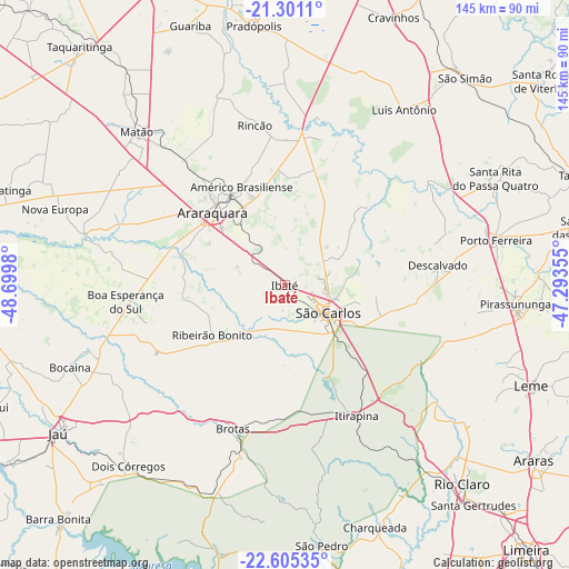
Ibaté GPS coordinates[2]
21° 57' 16.992" South, 47° 59' 48.012" West
| Map corner | latitude | longitude |
|---|---|---|
| Upper-left | -21.3011°, | -48.6998° |
| Center: | -21.95472°, | -47.99667° |
| Lower-right: | -22.60535°, | -47.29355° |
| Map W x H: | 145×145 km | = 90.1×90.1mi |
| max Lat: | 2.81972° ⇑69.7% North |
| Ibaté: | -21.95472° |
| min Lat: | ⇓30.3% South -33.69111° |
| min Long | Ibaté | max Long |
| -72.89583° | -47.99667° | -32.41083° |
| W 35.5%⇐ | ⇒64.5% E |
Elevation
Elevation of Ibaté is 849 m = 2785 ft, and this is 468.1 m = 1536 ft above average elevation for this country.
| Max E: |
1603 m = 5259 ft | 7.6% |
| Ibaté | 849 m 2785 ft | |
| Avg. | 380.9 m = 1250 ft | |
Min E: |
0 m = 0 ft | 92.4% |
See also: Brazil elevation on elevation.city.
Geographical zone
Ibaté is located in South Torrid zone (between Equator and Tropic of Capricorn). Distance of this Southern Tropic circle is 164.8 km =102.4 mi to South.| Distance of | km | miles | from Ibaté |
|---|---|---|---|
| Equator | 2441.1 | 1516.8 | to North |
| Tropic Capricorn | 164.8 | 102.4 | to South |
| Antarctic Circle | 4960 | 3082 | to South |
| South Pole | 7565.9 | 4701.2 | to South |


Nearby cities:
15 places around Ibaté: (largest is in red/bold)
• Américo Brasiliense
27.8 km =17.3 mi,  337°
337°
• Araraquara
25.7 km =16 mi,  313°
313°
• Boa Esperança do Sul
40.9 km =25.4 mi,  264°
264°
• Brotas
39 km =24.2 mi,  200°
200°
• Charqueada
65.7 km =40.8 mi,  159°
159°
• Descalvado
39.3 km =24.4 mi,  81°
81°
• Dois Córregos
60.4 km =37.5 mi,  220°
220°
• Itirapina
37.7 km =23.4 mi,  151°
151°
• Matão
54.6 km =33.9 mi,  315°
315°
• Pirassununga
59 km =36.7 mi,  94°
94°
• Porto Ferreira
54.6 km =33.9 mi, 78°
• Ribeirão Bonito
22.3 km =13.9 mi,  236°
236°
• Santa Rita do Passa Quatro
60 km =37.3 mi,  63°
63°
• São Carlos
13 km =8.1 mi,  122°
122°
• São Pedro
66.6 km =41.4 mi,  172°
172°
Sources, notices
• [Note1] Compared only with cities in Brazil existing in our database
• [Src1] Map data: © OpenStreetMap contributors (CC-BY-SA)
• [Src2] Other city data from geonames.org with taken over terms of usage.
• [Src3] Geographical zone / Annual Mean Temperature by Robert A. Rohde @ Wikipedia
