Nazaré geodata
Nazaré (Bahia) is a populated place; located in Brazil in America/Bahia (GMT-3) time zone. With population of 25,604 people, there are 769 cities with bigger population in this country. Compared to other cities in Brazil, 59.8% of cities are located further ↓South; 80.1% of cities are located further ←West and 93.2% of cities have higher elevation than Nazaré. Note1


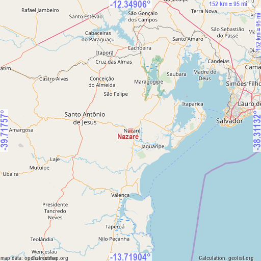
Nazaré GPS coordinates[2]
13° 2' 6" South, 39° 0' 51.984" West
| Map corner | latitude | longitude |
|---|---|---|
| Upper-left | -12.34906°, | -39.71757° |
| Center: | -13.035°, | -39.01444° |
| Lower-right: | -13.71904°, | -38.31132° |
| Map W x H: | 152.3×152.3 km | = 94.6×94.6mi |
| max Lat: | 2.81972° ⇑40.2% North |
| Nazaré: | -13.035° |
| min Lat: | ⇓59.8% South -33.69111° |
| min Long | Nazaré | max Long |
| -72.89583° | -39.01444° | -32.41083° |
| W 80.1%⇐ | ⇒19.9% E |
Elevation
Elevation of Nazaré is 12 m = 39 ft, and this is 368.9 m = 1210 ft below average elevation for this country.
| Max E: |
1603 m = 5259 ft | 93.2% |
| Avg. | 380.9 m = 1250 ft | |
| Nazaré | 12 m = 39 ft | |
Min E: |
0 m = 0 ft | 6.8% |
See also: Brazil elevation on elevation.city.
Geographical zone
Nazaré is located in South Torrid zone (between Equator and Tropic of Capricorn). Distance of this Southern Tropic circle is 1156.6 km =718.7 mi to South.| Distance of | km | miles | from Nazaré |
|---|---|---|---|
| Equator | 1449.4 | 900.6 | to North |
| Tropic Capricorn | 1156.6 | 718.7 | to South |
| Antarctic Circle | 5951.8 | 3698.3 | to South |
| South Pole | 8557.7 | 5317.5 | to South |


Nearby cities:
15 places around Nazaré: (largest is in red/bold)
• Cachoeira
48.5 km =30.1 mi,  6°
6°
• Castro Alves
53.9 km =33.5 mi,  303°
303°
• Conceição do Almeida
33 km =20.5 mi,  329°
329°
• Cruz das Almas
41.7 km =25.9 mi,  346°
346°
• Itaparica
39.9 km =24.8 mi,  65°
65°
• Madre de Deus
53.8 km =33.4 mi,  52°
52°
• Maragogipe
30.4 km =18.9 mi,  19°
19°
• Muritiba
28.7 km =17.8 mi, 297°
• Mutuípe
57.3 km =35.6 mi,  247°
247°
• Salvador
55 km =34.2 mi,  82°
82°
• Santo Antônio de Jesus
27.7 km =17.2 mi,  285°
285°
• Saubara
42.5 km =26.4 mi,  38°
38°
• Sobradinho
24.3 km =15.1 mi,  337°
337°
• Taperoá
56.7 km =35.2 mi,  189°
189°
• Valença
37.8 km =23.5 mi, 189°
Sources, notices
• [Note1] Compared only with cities in Brazil existing in our database
• [Src1] Map data: © OpenStreetMap contributors (CC-BY-SA)
• [Src2] Other city data from geonames.org with taken over terms of usage.
• [Src3] Geographical zone / Annual Mean Temperature by Robert A. Rohde @ Wikipedia
