Luz geodata
Luz (Minas Gerais) is a populated place; located in Brazil in America/Sao_Paulo (GMT-3) time zone. With population of 14,396 people, there are 1259 cities with bigger population in this country. Compared to other cities in Brazil, 55.9% of cities are located further ↑North; 51.5% of cities are located further →East and 79.3% of cities have lower elevation than Luz. Note1


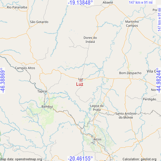
Luz GPS coordinates[2]
19° 48' 5.004" South, 45° 41' 8.016" West
| Map corner | latitude | longitude |
|---|---|---|
| Upper-left | -19.13848°, | -46.38869° |
| Center: | -19.80139°, | -45.68556° |
| Lower-right: | -20.46155°, | -44.98244° |
| Map W x H: | 147.1×147.1 km | = 91.4×91.4mi |
| max Lat: | 2.81972° ⇑55.9% North |
| Luz: | -19.80139° |
| min Lat: | ⇓44.1% South -33.69111° |
| min Long | Luz | max Long |
| -72.89583° | -45.68556° | -32.41083° |
| W 48.5%⇐ | ⇒51.5% E |
Elevation
Elevation of Luz is 679 m = 2228 ft, and this is 298.1 m = 978 ft above average elevation for this country.
| Max E: |
1603 m = 5259 ft | 20.7% |
| Luz | 679 m 2228 ft | |
| Avg. | 380.9 m = 1250 ft | |
Min E: |
0 m = 0 ft | 79.3% |
See also: Brazil elevation on elevation.city.
Geographical zone
Luz is located in South Torrid zone (between Equator and Tropic of Capricorn). Distance of this Southern Tropic circle is 404.2 km =251.2 mi to South.| Distance of | km | miles | from Luz |
|---|---|---|---|
| Equator | 2201.7 | 1368.1 | to North |
| Tropic Capricorn | 404.2 | 251.2 | to South |
| Antarctic Circle | 5199.5 | 3230.8 | to South |
| South Pole | 7805.4 | 4850 | to South |


Nearby cities:
15 places around Luz: (largest is in red/bold)
• Abaeté
75.6 km =47 mi,  19°
19°
• Arcos
55.6 km =34.5 mi,  164°
164°
• Bambuí
38 km =23.6 mi,  233°
233°
• Bom Despacho
45.9 km =28.5 mi,  80°
80°
• Campos Altos
52.2 km =32.4 mi,  282°
282°
• Divinópolis
91.4 km =56.8 mi,  114°
114°
• Dores do Indaiá
38.6 km =24 mi,  13°
13°
• Formiga
78.5 km =48.8 mi, 159°
• Itapecerica
94.8 km =58.9 mi,  141°
141°
• Lagoa da Prata
28.7 km =17.8 mi,  148°
148°
• Martinho Campos
70.3 km =43.7 mi,  41°
41°
• Pitangui
84.3 km =52.4 mi, 80°
• Piuí
79.1 km =49.2 mi,  201°
201°
• Santo Antônio do Monte
51.8 km =32.2 mi,  127°
127°
• São Gotardo
66.5 km =41.3 mi,  325°
325°
Sources, notices
• [Note1] Compared only with cities in Brazil existing in our database
• [Src1] Map data: © OpenStreetMap contributors (CC-BY-SA)
• [Src2] Other city data from geonames.org with taken over terms of usage.
• [Src3] Geographical zone / Annual Mean Temperature by Robert A. Rohde @ Wikipedia
