Bambuí geodata
Bambuí (Minas Gerais) is a populated place; located in Brazil in America/Sao_Paulo (GMT-3) time zone. With population of 18,840 people, there are 992 cities with bigger population in this country. Compared to other cities in Brazil, 57.1% of cities are located further ↑North; 52.3% of cities are located further →East and 80.8% of cities have lower elevation than Bambuí. Note1


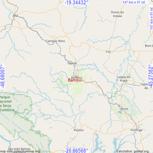
Bambuí GPS coordinates[2]
20° 0' 23.004" South, 45° 58' 36.984" West
| Map corner | latitude | longitude |
|---|---|---|
| Upper-left | -19.34432°, | -46.68007° |
| Center: | -20.00639°, | -45.97694° |
| Lower-right: | -20.66568°, | -45.27382° |
| Map W x H: | 146.9×146.9 km | = 91.3×91.3mi |
| max Lat: | 2.81972° ⇑57.1% North |
| Bambuí: | -20.00639° |
| min Lat: | ⇓42.9% South -33.69111° |
| min Long | Bambuí | max Long |
| -72.89583° | -45.97694° | -32.41083° |
| W 47.7%⇐ | ⇒52.3% E |
Elevation
Elevation of Bambuí is 700 m = 2297 ft, and this is 319.1 m = 1047 ft above average elevation for this country.
| Max E: |
1603 m = 5259 ft | 19.2% |
| Bambuí | 700 m 2297 ft | |
| Avg. | 380.9 m = 1250 ft | |
Min E: |
0 m = 0 ft | 80.8% |
See also: Brazil elevation on elevation.city.
Geographical zone
Bambuí is located in South Torrid zone (between Equator and Tropic of Capricorn). Distance of this Southern Tropic circle is 381.4 km =237 mi to South.| Distance of | km | miles | from Bambuí |
|---|---|---|---|
| Equator | 2224.5 | 1382.2 | to North |
| Tropic Capricorn | 381.4 | 237 | to South |
| Antarctic Circle | 5176.7 | 3216.7 | to South |
| South Pole | 7782.6 | 4835.9 | to South |


Nearby cities:
15 places around Bambuí: (largest is in red/bold)
• Alpinópolis
104.5 km =64.9 mi,  204°
204°
• Arcos
55 km =34.2 mi,  123°
123°
• Bom Despacho
81.5 km =50.6 mi,  68°
68°
• Campos Altos
40 km =24.9 mi,  329°
329°
• Capitólio
68.1 km =42.3 mi,  186°
186°
• Dores do Indaiá
72 km =44.7 mi,  33°
33°
• Formiga
76.8 km =47.7 mi,  131°
131°
• Ibiá
83.1 km =51.6 mi,  314°
314°
• Itapecerica
102.8 km =63.9 mi, 120°
• Lagoa da Prata
45.3 km =28.1 mi,  92°
92°
• Luz
38 km =23.6 mi,  53°
53°
• Passos
103.1 km =64.1 mi,  219°
219°
• Piuí
51.1 km =31.8 mi,  177°
177°
• Santo Antônio do Monte
71.9 km =44.7 mi,  97°
97°
• São Gotardo
77.7 km =48.3 mi,  354°
354°
Sources, notices
• [Note1] Compared only with cities in Brazil existing in our database
• [Src1] Map data: © OpenStreetMap contributors (CC-BY-SA)
• [Src2] Other city data from geonames.org with taken over terms of usage.
• [Src3] Geographical zone / Annual Mean Temperature by Robert A. Rohde @ Wikipedia
