Formiga geodata
Formiga (Minas Gerais) is a populated place; located in Brazil in America/Sao_Paulo (GMT-3) time zone. With population of 56,404 people, there are 389 cities with bigger population in this country. Compared to other cities in Brazil, 60% of cities are located further ↑North; 50.7% of cities are located further →East and 91.8% of cities have lower elevation than Formiga. Note1


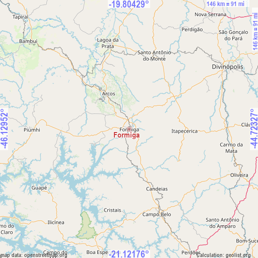
Formiga GPS coordinates[2]
20° 27' 51.984" South, 45° 25' 35.004" West
| Map corner | latitude | longitude |
|---|---|---|
| Upper-left | -19.80429°, | -46.12952° |
| Center: | -20.46444°, | -45.42639° |
| Lower-right: | -21.12176°, | -44.72327° |
| Map W x H: | 146.5×146.5 km | = 91×91mi |
| max Lat: | 2.81972° ⇑60% North |
| Formiga: | -20.46444° |
| min Lat: | ⇓40% South -33.69111° |
| min Long | Formiga | max Long |
| -72.89583° | -45.42639° | -32.41083° |
| W 49.3%⇐ | ⇒50.7% E |
Elevation
Elevation of Formiga is 841 m = 2759 ft, and this is 460.1 m = 1510 ft above average elevation for this country.
| Max E: |
1603 m = 5259 ft | 8.2% |
| Formiga | 841 m 2759 ft | |
| Avg. | 380.9 m = 1250 ft | |
Min E: |
0 m = 0 ft | 91.8% |
See also: Formiga elevation on elevation.city.
Geographical zone
Formiga is located in South Torrid zone (between Equator and Tropic of Capricorn). Distance of this Southern Tropic circle is 330.5 km =205.4 mi to South.| Distance of | km | miles | from Formiga |
|---|---|---|---|
| Equator | 2275.4 | 1413.9 | to North |
| Tropic Capricorn | 330.5 | 205.4 | to South |
| Antarctic Circle | 5125.7 | 3185 | to South |
| South Pole | 7731.6 | 4804.2 | to South |


Nearby cities:
15 places around Formiga: (largest is in red/bold)
• Arcos
23.5 km =14.6 mi,  329°
329°
• Bambuí
76.8 km =47.7 mi,  311°
311°
• Boa Esperança
71.1 km =44.2 mi,  191°
191°
• Campo Belo
50.6 km =31.4 mi,  162°
162°
• Capitólio
67.1 km =41.7 mi,  255°
255°
• Carmo do Cajuru
75.1 km =46.7 mi,  65°
65°
• Cláudio
68.9 km =42.8 mi,  88°
88°
• Divinópolis
66.3 km =41.2 mi,  57°
57°
• Itapecerica
31.4 km =19.5 mi, 91°
• Lagoa da Prata
50.6 km =31.4 mi,  346°
346°
• Oliveira
67.5 km =41.9 mi,  112°
112°
• Perdões
77.9 km =48.4 mi,  153°
153°
• Piuí
55.4 km =34.4 mi,  269°
269°
• Santo Antônio do Amparo
75.2 km =46.7 mi,  135°
135°
• Santo Antônio do Monte
44.2 km =27.5 mi,  18°
18°
Sources, notices
• [Note1] Compared only with cities in Brazil existing in our database
• [Src1] Map data: © OpenStreetMap contributors (CC-BY-SA)
• [Src2] Other city data from geonames.org with taken over terms of usage.
• [Src3] Geographical zone / Annual Mean Temperature by Robert A. Rohde @ Wikipedia
