Itapira geodata
Itapira (São Paulo) is a populated place; located in Brazil in America/Sao_Paulo (GMT-3) time zone. With population of 61,607 people, there are 364 cities with bigger population in this country. Compared to other cities in Brazil, 73.1% of cities are located further ↑North; 57.1% of cities are located further →East and 76.6% of cities have lower elevation than Itapira. Note1


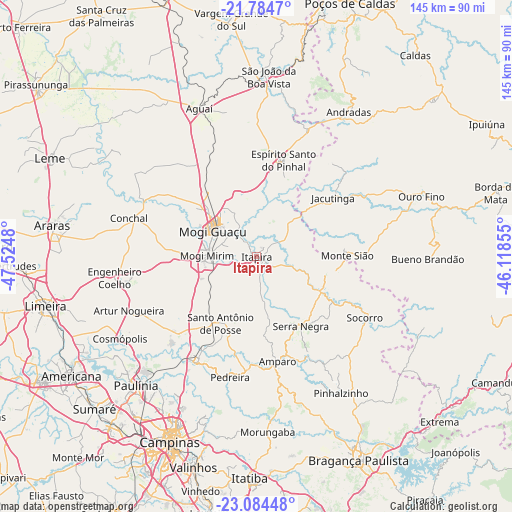
Itapira GPS coordinates[2]
22° 26' 9.996" South, 46° 49' 18.012" West
| Map corner | latitude | longitude |
|---|---|---|
| Upper-left | -21.7847°, | -47.5248° |
| Center: | -22.43611°, | -46.82167° |
| Lower-right: | -23.08448°, | -46.11855° |
| Map W x H: | 144.5×144.5 km | = 89.8×89.8mi |
| max Lat: | 2.81972° ⇑73.1% North |
| Itapira: | -22.43611° |
| min Lat: | ⇓26.9% South -33.69111° |
| min Long | Itapira | max Long |
| -72.89583° | -46.82167° | -32.41083° |
| W 42.9%⇐ | ⇒57.1% E |
Elevation
Elevation of Itapira is 649 m = 2129 ft, and this is 268.1 m = 880 ft above average elevation for this country.
| Max E: |
1603 m = 5259 ft | 23.4% |
| Itapira | 649 m 2129 ft | |
| Avg. | 380.9 m = 1250 ft | |
Min E: |
0 m = 0 ft | 76.6% |
See also: Itapira elevation on elevation.city.
Geographical zone
Itapira is located in South Torrid zone (between Equator and Tropic of Capricorn). Distance of this Southern Tropic circle is 111.3 km =69.2 mi to South.| Distance of | km | miles | from Itapira |
|---|---|---|---|
| Equator | 2494.7 | 1550.1 | to North |
| Tropic Capricorn | 111.3 | 69.2 | to South |
| Antarctic Circle | 4906.5 | 3048.8 | to South |
| South Pole | 7512.4 | 4668 | to South |


Nearby cities:
15 places around Itapira: (largest is in red/bold)
• Aguaí
44.9 km =27.9 mi,  338°
338°
• Amparo
30 km =18.6 mi,  168°
168°
• Artur Nogueira
39.1 km =24.3 mi,  247°
247°
• Conchal
37.9 km =23.5 mi,  288°
288°
• Espírito Santo do Pinhal
38.4 km =23.9 mi,  21°
21°
• Jacutinga
27.3 km =17 mi,  52°
52°
• Jaguariúna
34.4 km =21.4 mi,  209°
209°
• Mogi Guaçu
14.8 km =9.2 mi,  300°
300°
• Mogi Mirim
14 km =8.7 mi,  271°
271°
• Monte Sião
25.6 km =15.9 mi,  89°
89°
• Pedreira
35 km =21.7 mi,  193°
193°
• Santo Antônio de Posse
21.4 km =13.3 mi, 207°
• Serra Negra
23.2 km =14.4 mi,  147°
147°
• Socorro
34.7 km =21.6 mi,  119°
119°
• Águas de Lindóia
19.9 km =12.4 mi,  102°
102°
Sources, notices
• [Note1] Compared only with cities in Brazil existing in our database
• [Src1] Map data: © OpenStreetMap contributors (CC-BY-SA)
• [Src2] Other city data from geonames.org with taken over terms of usage.
• [Src3] Geographical zone / Annual Mean Temperature by Robert A. Rohde @ Wikipedia
