Pedreira geodata
Pedreira (São Paulo) is a populated place; located in Brazil in America/Sao_Paulo (GMT-3) time zone. With population of 39,198 people, there are 534 cities with bigger population in this country. Compared to other cities in Brazil, 75.9% of cities are located further ↑North; 57.7% of cities are located further →East and 72.8% of cities have lower elevation than Pedreira. Note1


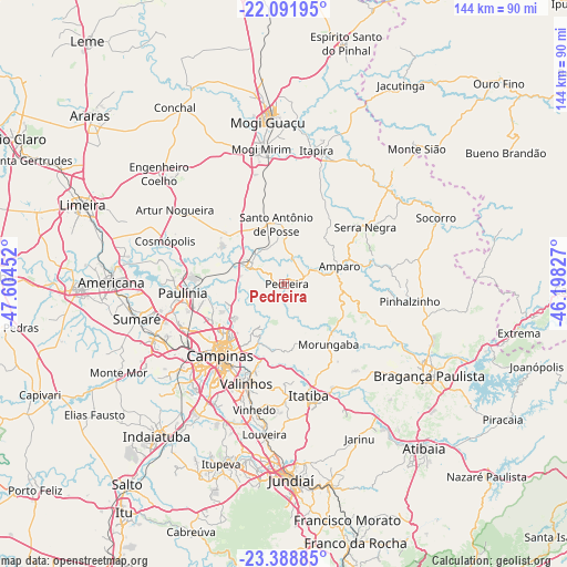
Pedreira GPS coordinates[2]
22° 44' 30.984" South, 46° 54' 5.004" West
| Map corner | latitude | longitude |
|---|---|---|
| Upper-left | -22.09195°, | -47.60452° |
| Center: | -22.74194°, | -46.90139° |
| Lower-right: | -23.38885°, | -46.19827° |
| Map W x H: | 144.2×144.2 km | = 89.6×89.6mi |
| max Lat: | 2.81972° ⇑75.9% North |
| Pedreira: | -22.74194° |
| min Lat: | ⇓24.1% South -33.69111° |
| min Long | Pedreira | max Long |
| -72.89583° | -46.90139° | -32.41083° |
| W 42.3%⇐ | ⇒57.7% E |
Elevation
Elevation of Pedreira is 601 m = 1972 ft, and this is 220.1 m = 722 ft above average elevation for this country.
| Max E: |
1603 m = 5259 ft | 27.2% |
| Pedreira | 601 m 1972 ft | |
| Avg. | 380.9 m = 1250 ft | |
Min E: |
0 m = 0 ft | 72.8% |
See also: Brazil elevation on elevation.city.
Geographical zone
Pedreira is located in South Torrid zone (between Equator and Tropic of Capricorn). Distance of this Southern Tropic circle is 77.3 km =48 mi to South.| Distance of | km | miles | from Pedreira |
|---|---|---|---|
| Equator | 2528.7 | 1571.3 | to North |
| Tropic Capricorn | 77.3 | 48 | to South |
| Antarctic Circle | 4872.5 | 3027.6 | to South |
| South Pole | 7478.4 | 4646.9 | to South |


Nearby cities:
15 places around Pedreira: (largest is in red/bold)
• Amparo
14.8 km =9.2 mi,  72°
72°
• Artur Nogueira
33.6 km =20.9 mi,  304°
304°
• Campinas
24.5 km =15.2 mi,  221°
221°
• Cosmópolis
32.1 km =19.9 mi,  289°
289°
• Hortolândia
35.1 km =21.8 mi,  248°
248°
• Itapira
35 km =21.7 mi,  13°
13°
• Itatiba
30 km =18.6 mi,  167°
167°
• Jaguariúna
9.6 km =6 mi, 295°
• Mogi Mirim
35 km =21.7 mi,  350°
350°
• Paulínia
26 km =16.2 mi,  265°
265°
• Santo Antônio de Posse
15.2 km =9.4 mi, 353°
• Serra Negra
25.2 km =15.7 mi,  55°
55°
• Sumaré
38.5 km =23.9 mi,  256°
256°
• Valinhos
27.2 km =16.9 mi,  200°
200°
• Vinhedo
32.9 km =20.4 mi,  193°
193°
Sources, notices
• [Note1] Compared only with cities in Brazil existing in our database
• [Src1] Map data: © OpenStreetMap contributors (CC-BY-SA)
• [Src2] Other city data from geonames.org with taken over terms of usage.
• [Src3] Geographical zone / Annual Mean Temperature by Robert A. Rohde @ Wikipedia
