Serra Negra geodata
Serra Negra (São Paulo) is a seat of a second-order administrative division; located in Brazil in America/Sao_Paulo (GMT-3) time zone. With population of 22,632 people, there are 846 cities with bigger population in this country. Compared to other cities in Brazil, 74.9% of cities are located further ↑North; 56.2% of cities are located further →East and 96.9% of cities have lower elevation than Serra Negra. Note1


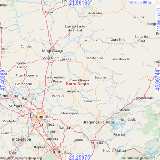
Serra Negra GPS coordinates[2]
22° 36' 43.992" South, 46° 42' 2.016" West
| Map corner | latitude | longitude |
|---|---|---|
| Upper-left | -21.96163°, | -47.40369° |
| Center: | -22.61222°, | -46.70056° |
| Lower-right: | -23.25975°, | -45.99744° |
| Map W x H: | 144.3×144.3 km | = 89.7×89.7mi |
| max Lat: | 2.81972° ⇑74.9% North |
| Serra Negra: | -22.61222° |
| min Lat: | ⇓25.1% South -33.69111° |
| min Long | Serra Negra | max Long |
| -72.89583° | -46.70056° | -32.41083° |
| W 43.8%⇐ | ⇒56.2% E |
Elevation
Elevation of Serra Negra is 937 m = 3074 ft, and this is 556.1 m = 1824 ft above average elevation for this country.
| Max E: |
1603 m = 5259 ft | 3.1% |
| Serra Negra | 937 m 3074 ft | |
| Avg. | 380.9 m = 1250 ft | |
Min E: |
0 m = 0 ft | 96.9% |
See also: Brazil elevation on elevation.city.
Geographical zone
Serra Negra is located in South Torrid zone (between Equator and Tropic of Capricorn). Distance of this Southern Tropic circle is 91.7 km =57 mi to South.| Distance of | km | miles | from Serra Negra |
|---|---|---|---|
| Equator | 2514.2 | 1562.3 | to North |
| Tropic Capricorn | 91.7 | 57 | to South |
| Antarctic Circle | 4886.9 | 3036.6 | to South |
| South Pole | 7492.8 | 4655.8 | to South |


Nearby cities:
15 places around Serra Negra: (largest is in red/bold)
• Amparo
11.9 km =7.4 mi,  213°
213°
• Bragança Paulista
41.1 km =25.5 mi,  157°
157°
• Bueno Brandão
40.7 km =25.3 mi,  62°
62°
• Extrema
47.6 km =29.6 mi,  124°
124°
• Itapira
23.2 km =14.4 mi,  327°
327°
• Itatiba
46 km =28.6 mi,  197°
197°
• Jacutinga
37.4 km =23.2 mi,  14°
14°
• Jaguariúna
31.1 km =19.3 mi,  250°
250°
• Mogi Guaçu
37 km =23 mi,  317°
317°
• Mogi Mirim
33.2 km =20.6 mi,  307°
307°
• Monte Sião
23.9 km =14.9 mi,  33°
33°
• Pedreira
25.2 km =15.7 mi,  235°
235°
• Santo Antônio de Posse
22.5 km =14 mi,  271°
271°
• Socorro
17.8 km =11.1 mi,  82°
82°
• Águas de Lindóia
16.6 km =10.3 mi,  24°
24°
Sources, notices
• [Note1] Compared only with cities in Brazil existing in our database
• [Src1] Map data: © OpenStreetMap contributors (CC-BY-SA)
• [Src2] Other city data from geonames.org with taken over terms of usage.
• [Src3] Geographical zone / Annual Mean Temperature by Robert A. Rohde @ Wikipedia
