Cambuci geodata
Cambuci (Rio de Janeiro) is a populated place; located in Brazil in America/Sao_Paulo (GMT-3) time zone. With population of 9,395 people, there are 1694 cities with bigger population in this country. Compared to other cities in Brazil, 67.1% of cities are located further ↑North; 66.2% of cities are located further ←West and 78.9% of cities have higher elevation than Cambuci. Note1


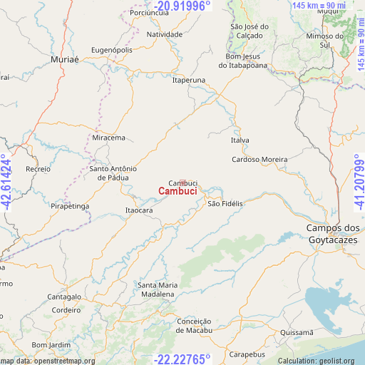
Cambuci GPS coordinates[2]
21° 34' 31.008" South, 41° 54' 39.996" West
| Map corner | latitude | longitude |
|---|---|---|
| Upper-left | -20.91996°, | -42.61424° |
| Center: | -21.57528°, | -41.91111° |
| Lower-right: | -22.22765°, | -41.20799° |
| Map W x H: | 145.4×145.4 km | = 90.3×90.3mi |
| max Lat: | 2.81972° ⇑67.1% North |
| Cambuci: | -21.57528° |
| min Lat: | ⇓32.9% South -33.69111° |
| min Long | Cambuci | max Long |
| -72.89583° | -41.91111° | -32.41083° |
| W 66.2%⇐ | ⇒33.8% E |
Elevation
Elevation of Cambuci is 53 m = 174 ft, and this is 327.9 m = 1076 ft below average elevation for this country.
| Max E: |
1603 m = 5259 ft | 78.9% |
| Avg. | 380.9 m = 1250 ft | |
| Cambuci | 53 m = 174 ft | |
Min E: |
0 m = 0 ft | 21.1% |
See also: Brazil elevation on elevation.city.
Geographical zone
Cambuci is located in South Torrid zone (between Equator and Tropic of Capricorn). Distance of this Southern Tropic circle is 207 km =128.6 mi to South.| Distance of | km | miles | from Cambuci |
|---|---|---|---|
| Equator | 2398.9 | 1490.6 | to North |
| Tropic Capricorn | 207 | 128.6 | to South |
| Antarctic Circle | 5002.2 | 3108.2 | to South |
| South Pole | 7608.1 | 4727.5 | to South |


Nearby cities:
15 places around Cambuci: (largest is in red/bold)
• Bom Jesus do Itabapoana
54.6 km =33.9 mi,  26°
26°
• Campos dos Goytacazes
63.1 km =39.2 mi,  108°
108°
• Cantagalo
65.3 km =40.6 mi,  226°
226°
• Cordeiro
68.5 km =42.6 mi,  222°
222°
• Itaocara
20 km =12.4 mi,  238°
238°
• Itaperuna
41.2 km =25.6 mi,  3°
3°
• Leopoldina
75.8 km =47.1 mi,  273°
273°
• Miracema
34.7 km =21.6 mi,  301°
301°
• Muriaé
68.3 km =42.4 mi,  316°
316°
• Natividade
59.6 km =37 mi,  353°
353°
• Porciúncula
69.4 km =43.1 mi, 348°
• Recreio
58 km =36 mi,  275°
275°
• Santo Antônio de Pádua
28.1 km =17.5 mi, 278°
• São Fidélis
18.7 km =11.6 mi, 114°
• São José do Calçado
66.7 km =41.4 mi,  23°
23°
Sources, notices
• [Note1] Compared only with cities in Brazil existing in our database
• [Src1] Map data: © OpenStreetMap contributors (CC-BY-SA)
• [Src2] Other city data from geonames.org with taken over terms of usage.
• [Src3] Geographical zone / Annual Mean Temperature by Robert A. Rohde @ Wikipedia
