Muriaé geodata
Muriaé (Minas Gerais) is a populated place; located in Brazil in America/Sao_Paulo (GMT-3) time zone. With population of 91,173 people, there are 251 cities with bigger population in this country. Compared to other cities in Brazil, 63.9% of cities are located further ↑North; 64.2% of cities are located further ←West and 60.1% of cities have higher elevation than Muriaé. Note1


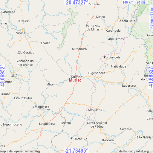
Muriaé GPS coordinates[2]
21° 7' 50.016" South, 42° 21' 59.004" West
| Map corner | latitude | longitude |
|---|---|---|
| Upper-left | -20.47327°, | -43.06952° |
| Center: | -21.13056°, | -42.36639° |
| Lower-right: | -21.78495°, | -41.66327° |
| Map W x H: | 145.8×145.8 km | = 90.6×90.6mi |
| max Lat: | 2.81972° ⇑63.9% North |
| Muriaé: | -21.13056° |
| min Lat: | ⇓36.1% South -33.69111° |
| min Long | Muriaé | max Long |
| -72.89583° | -42.36639° | -32.41083° |
| W 64.2%⇐ | ⇒35.8% E |
Elevation
Elevation of Muriaé is 212 m = 696 ft, and this is 168.9 m = 554 ft below average elevation for this country.
| Max E: |
1603 m = 5259 ft | 60.1% |
| Avg. | 380.9 m = 1250 ft | |
| Muriaé | 212 m = 696 ft | |
Min E: |
0 m = 0 ft | 39.9% |
See also: Muriaé elevation on elevation.city.
Geographical zone
Muriaé is located in South Torrid zone (between Equator and Tropic of Capricorn). Distance of this Southern Tropic circle is 256.4 km =159.3 mi to South.| Distance of | km | miles | from Muriaé |
|---|---|---|---|
| Equator | 2349.5 | 1459.9 | to North |
| Tropic Capricorn | 256.4 | 159.3 | to South |
| Antarctic Circle | 5051.7 | 3139 | to South |
| South Pole | 7657.6 | 4758.2 | to South |


Nearby cities:
15 places around Muriaé: (largest is in red/bold)
• Astolfo Dutra
55.3 km =34.4 mi,  248°
248°
• Carangola
56.4 km =35 mi,  38°
38°
• Cataguases
44.7 km =27.8 mi,  229°
229°
• Itaocara
67 km =41.6 mi,  153°
153°
• Itaperuna
50.3 km =31.3 mi,  99°
99°
• Leopoldina
53 km =32.9 mi,  212°
212°
• Miracema
35.9 km =22.3 mi, 150°
• Miraí
26.7 km =16.6 mi, 254°
• Natividade
41.9 km =26 mi,  76°
76°
• Porciúncula
38.6 km =24 mi,  61°
61°
• Recreio
45.1 km =28 mi,  193°
193°
• Santo Antônio de Pádua
49.4 km =30.7 mi,  157°
157°
• Tocantins
67.7 km =42.1 mi,  265°
265°
• Ubá
59.8 km =37.2 mi, 271°
• Visconde do Rio Branco
51 km =31.7 mi,  285°
285°
Sources, notices
• [Note1] Compared only with cities in Brazil existing in our database
• [Src1] Map data: © OpenStreetMap contributors (CC-BY-SA)
• [Src2] Other city data from geonames.org with taken over terms of usage.
• [Src3] Geographical zone / Annual Mean Temperature by Robert A. Rohde @ Wikipedia
