Itaperuna geodata
Itaperuna (Rio de Janeiro) is a populated place; located in Brazil in America/Sao_Paulo (GMT-3) time zone. With population of 84,435 people, there are 274 cities with bigger population in this country. Compared to other cities in Brazil, 64.6% of cities are located further ↑North; 66.4% of cities are located further ←West and 70.1% of cities have higher elevation than Itaperuna. Note1


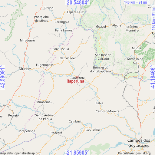
Itaperuna GPS coordinates[2]
21° 12' 18" South, 41° 53' 16.008" West
| Map corner | latitude | longitude |
|---|---|---|
| Upper-left | -20.54804°, | -42.59091° |
| Center: | -21.205°, | -41.88778° |
| Lower-right: | -21.85905°, | -41.18466° |
| Map W x H: | 145.8×145.8 km | = 90.6×90.6mi |
| max Lat: | 2.81972° ⇑64.6% North |
| Itaperuna: | -21.205° |
| min Lat: | ⇓35.4% South -33.69111° |
| min Long | Itaperuna | max Long |
| -72.89583° | -41.88778° | -32.41083° |
| W 66.4%⇐ | ⇒33.6% E |
Elevation
Elevation of Itaperuna is 123 m = 404 ft, and this is 257.9 m = 846 ft below average elevation for this country.
| Max E: |
1603 m = 5259 ft | 70.1% |
| Avg. | 380.9 m = 1250 ft | |
| Itaperuna | 123 m = 404 ft | |
Min E: |
0 m = 0 ft | 29.9% |
See also: Itaperuna elevation on elevation.city.
Geographical zone
Itaperuna is located in South Torrid zone (between Equator and Tropic of Capricorn). Distance of this Southern Tropic circle is 248.1 km =154.2 mi to South.| Distance of | km | miles | from Itaperuna |
|---|---|---|---|
| Equator | 2357.8 | 1465.1 | to North |
| Tropic Capricorn | 248.1 | 154.2 | to South |
| Antarctic Circle | 5043.4 | 3133.8 | to South |
| South Pole | 7649.3 | 4753.1 | to South |


Nearby cities:
15 places around Itaperuna: (largest is in red/bold)
• Alegre
61.4 km =38.2 mi,  36°
36°
• Bom Jesus do Itabapoana
23 km =14.3 mi,  69°
69°
• Cambuci
41.2 km =25.6 mi,  183°
183°
• Carangola
54.5 km =33.9 mi,  344°
344°
• Espera Feliz
61.7 km =38.3 mi,  358°
358°
• Guaçuí
52.4 km =32.6 mi,  24°
24°
• Itaocara
55.2 km =34.3 mi,  200°
200°
• Mimoso do Sul
56.3 km =35 mi, 73°
• Miracema
39.4 km =24.5 mi,  234°
234°
• Muriaé
50.3 km =31.3 mi,  279°
279°
• Natividade
20.2 km =12.6 mi,  333°
333°
• Porciúncula
31.3 km =19.4 mi, 329°
• Santo Antônio de Pádua
48 km =29.8 mi,  219°
219°
• São Fidélis
51.2 km =31.8 mi,  163°
163°
• São José do Calçado
31.4 km =19.5 mi,  50°
50°
Sources, notices
• [Note1] Compared only with cities in Brazil existing in our database
• [Src1] Map data: © OpenStreetMap contributors (CC-BY-SA)
• [Src2] Other city data from geonames.org with taken over terms of usage.
• [Src3] Geographical zone / Annual Mean Temperature by Robert A. Rohde @ Wikipedia
