Itagibá geodata
Itagibá (Bahia) is a populated place; located in Brazil in America/Bahia (GMT-3) time zone. With population of 9,843 people, there are 1662 cities with bigger population in this country. Compared to other cities in Brazil, 57.6% of cities are located further ↓South; 75.9% of cities are located further ←West and 62.1% of cities have higher elevation than Itagibá. Note1


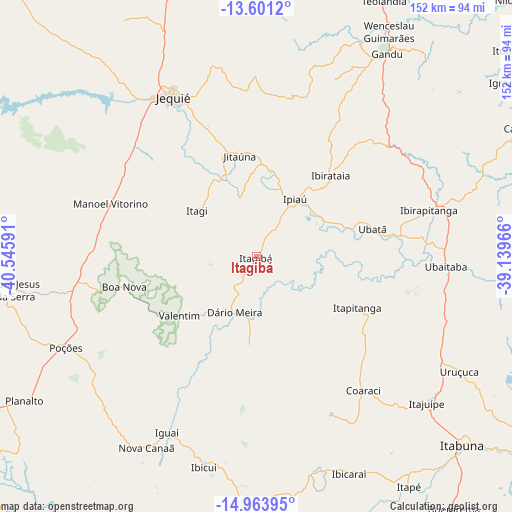
Itagibá GPS coordinates[2]
14° 17' 0.996" South, 39° 50' 34.008" West
| Map corner | latitude | longitude |
|---|---|---|
| Upper-left | -13.6012°, | -40.54591° |
| Center: | -14.28361°, | -39.84278° |
| Lower-right: | -14.96395°, | -39.13966° |
| Map W x H: | 151.5×151.5 km | = 94.1×94.1mi |
| max Lat: | 2.81972° ⇑42.4% North |
| Itagibá: | -14.28361° |
| min Lat: | ⇓57.6% South -33.69111° |
| min Long | Itagibá | max Long |
| -72.89583° | -39.84278° | -32.41083° |
| W 75.9%⇐ | ⇒24.1% E |
Elevation
Elevation of Itagibá is 192 m = 630 ft, and this is 188.9 m = 620 ft below average elevation for this country.
| Max E: |
1603 m = 5259 ft | 62.1% |
| Avg. | 380.9 m = 1250 ft | |
| Itagibá | 192 m = 630 ft | |
Min E: |
0 m = 0 ft | 37.9% |
See also: Brazil elevation on elevation.city.
Geographical zone
Itagibá is located in South Torrid zone (between Equator and Tropic of Capricorn). Distance of this Southern Tropic circle is 1017.7 km =632.4 mi to South.| Distance of | km | miles | from Itagibá |
|---|---|---|---|
| Equator | 1588.2 | 986.9 | to North |
| Tropic Capricorn | 1017.7 | 632.4 | to South |
| Antarctic Circle | 5813 | 3612 | to South |
| South Pole | 8418.9 | 5231.3 | to South |


Nearby cities:
15 places around Itagibá: (largest is in red/bold)
• Coaraci
50.6 km =31.4 mi,  141°
141°
• Ibicaraí
70.2 km =43.6 mi,  156°
156°
• Ibicuí
64 km =39.8 mi,  194°
194°
• Ibirapitanga
52.3 km =32.5 mi,  75°
75°
• Ibirataia
32.5 km =20.2 mi,  42°
42°
• Iguaí
58.9 km =36.6 mi,  206°
206°
• Ipiaú
20 km =12.4 mi,  33°
33°
• Itagi
22.1 km =13.7 mi,  307°
307°
• Itajuípe
66.8 km =41.5 mi,  131°
131°
• Jequié
54 km =33.6 mi,  331°
331°
• Jitaúna
30.7 km =19.1 mi,  348°
348°
• Poções
62.6 km =38.9 mi,  244°
244°
• Ubaitaba
56.1 km =34.9 mi,  93°
93°
• Ubatã
35.1 km =21.8 mi, 76°
• Uruçuca
69.3 km =43.1 mi,  119°
119°
Sources, notices
• [Note1] Compared only with cities in Brazil existing in our database
• [Src1] Map data: © OpenStreetMap contributors (CC-BY-SA)
• [Src2] Other city data from geonames.org with taken over terms of usage.
• [Src3] Geographical zone / Annual Mean Temperature by Robert A. Rohde @ Wikipedia
