Iguaí geodata
Iguaí (Bahia) is a populated place; located in Brazil in America/Bahia (GMT-3) time zone. With population of 14,217 people, there are 1273 cities with bigger population in this country. Compared to other cities in Brazil, 56.7% of cities are located further ↓South; 75.1% of cities are located further ←West and 50.1% of cities have lower elevation than Iguaí. Note1


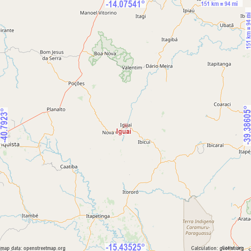
Iguaí GPS coordinates[2]
14° 45' 23.004" South, 40° 5' 21.012" West
| Map corner | latitude | longitude |
|---|---|---|
| Upper-left | -14.07541°, | -40.7923° |
| Center: | -14.75639°, | -40.08917° |
| Lower-right: | -15.43525°, | -39.38605° |
| Map W x H: | 151.2×151.2 km | = 94×94mi |
| max Lat: | 2.81972° ⇑43.3% North |
| Iguaí: | -14.75639° |
| min Lat: | ⇓56.7% South -33.69111° |
| min Long | Iguaí | max Long |
| -72.89583° | -40.08917° | -32.41083° |
| W 75.1%⇐ | ⇒24.9% E |
Elevation
Elevation of Iguaí is 354 m = 1161 ft, and this is 26.9 m = 88 ft below average elevation for this country.
| Max E: |
1603 m = 5259 ft | 49.9% |
| Avg. | 380.9 m = 1250 ft | |
| Iguaí | 354 m = 1161 ft | |
Min E: |
0 m = 0 ft | 50.1% |
See also: Brazil elevation on elevation.city.
Geographical zone
Iguaí is located in South Torrid zone (between Equator and Tropic of Capricorn). Distance of this Southern Tropic circle is 965.2 km =599.7 mi to South.| Distance of | km | miles | from Iguaí |
|---|---|---|---|
| Equator | 1640.8 | 1019.5 | to North |
| Tropic Capricorn | 965.2 | 599.7 | to South |
| Antarctic Circle | 5760.4 | 3579.3 | to South |
| South Pole | 8366.3 | 5198.6 | to South |


Nearby cities:
15 places around Iguaí: (largest is in red/bold)
• Coaraci
59.3 km =36.8 mi,  77°
77°
• Ibicaraí
55.3 km =34.4 mi,  102°
102°
• Ibicuí
14.5 km =9 mi,  130°
130°
• Ipiaú
78.7 km =48.9 mi,  28°
28°
• Itabuna
87 km =54.1 mi,  92°
92°
• Itagi
66.6 km =41.4 mi,  7°
7°
• Itagibá
58.9 km =36.6 mi, 26°
• Itajuípe
77.3 km =48 mi, 83°
• Itambé
79.1 km =49.2 mi,  226°
226°
• Itapetinga
57.3 km =35.6 mi,  197°
197°
• Itororó
40.1 km =24.9 mi,  177°
177°
• Jitaúna
85.2 km =52.9 mi, 13°
• Poções
39 km =24.2 mi,  310°
310°
• Ubatã
85.9 km =53.4 mi,  44°
44°
• Vitória da Conquista
81.6 km =50.7 mi,  261°
261°
Sources, notices
• [Note1] Compared only with cities in Brazil existing in our database
• [Src1] Map data: © OpenStreetMap contributors (CC-BY-SA)
• [Src2] Other city data from geonames.org with taken over terms of usage.
• [Src3] Geographical zone / Annual Mean Temperature by Robert A. Rohde @ Wikipedia
