Ipiaú geodata
Ipiaú (Bahia) is a populated place; located in Brazil in America/Bahia (GMT-3) time zone. With population of 38,762 people, there are 540 cities with bigger population in this country. Compared to other cities in Brazil, 58% of cities are located further ↓South; 76.2% of cities are located further ←West and 68.2% of cities have higher elevation than Ipiaú. Note1


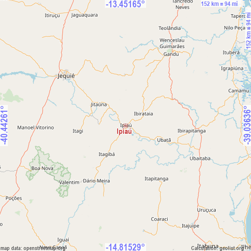
Ipiaú GPS coordinates[2]
14° 8' 4.164" South, 39° 44' 22.128" West
| Map corner | latitude | longitude |
|---|---|---|
| Upper-left | -13.45165°, | -40.44261° |
| Center: | -14.13449°, | -39.73948° |
| Lower-right: | -14.81529°, | -39.03636° |
| Map W x H: | 151.6×151.6 km | = 94.2×94.2mi |
| max Lat: | 2.81972° ⇑42% North |
| Ipiaú: | -14.13449° |
| min Lat: | ⇓58% South -33.69111° |
| min Long | Ipiaú | max Long |
| -72.89583° | -39.73948° | -32.41083° |
| W 76.2%⇐ | ⇒23.8% E |
Elevation
Elevation of Ipiaú is 140 m = 459 ft, and this is 240.9 m = 790 ft below average elevation for this country.
| Max E: |
1603 m = 5259 ft | 68.2% |
| Avg. | 380.9 m = 1250 ft | |
| Ipiaú | 140 m = 459 ft | |
Min E: |
0 m = 0 ft | 31.8% |
See also: Brazil elevation on elevation.city.
Geographical zone
Ipiaú is located in South Torrid zone (between Equator and Tropic of Capricorn). Distance of this Southern Tropic circle is 1034.3 km =642.7 mi to South.| Distance of | km | miles | from Ipiaú |
|---|---|---|---|
| Equator | 1571.6 | 976.5 | to North |
| Tropic Capricorn | 1034.3 | 642.7 | to South |
| Antarctic Circle | 5829.6 | 3622.3 | to South |
| South Pole | 8435.5 | 5241.6 | to South |


Nearby cities:
15 places around Ipiaú: (largest is in red/bold)
• Camamu
71.7 km =44.6 mi,  72°
72°
• Coaraci
59.8 km =37.2 mi,  160°
160°
• Gandu
51.3 km =31.9 mi,  32°
32°
• Ibirapitanga
39.6 km =24.6 mi,  94°
94°
• Ibirataia
13 km =8.1 mi,  54°
54°
• Itagi
28.9 km =18 mi,  263°
263°
• Itagibá
20 km =12.4 mi,  213°
213°
• Itajuípe
72.1 km =44.8 mi,  146°
146°
• Ituberá
77.8 km =48.3 mi,  55°
55°
• Jaguaquara
71.6 km =44.5 mi,  339°
339°
• Jequié
48.3 km =30 mi,  309°
309°
• Jitaúna
21.8 km =13.5 mi, 308°
• Ubaitaba
49 km =30.4 mi,  113°
113°
• Ubatã
24.4 km =15.2 mi, 109°
• Uruçuca
70.7 km =43.9 mi,  136°
136°
Sources, notices
• [Note1] Compared only with cities in Brazil existing in our database
• [Src1] Map data: © OpenStreetMap contributors (CC-BY-SA)
• [Src2] Other city data from geonames.org with taken over terms of usage.
• [Src3] Geographical zone / Annual Mean Temperature by Robert A. Rohde @ Wikipedia
