Jequié geodata
Jequié (Bahia) is a populated place; located in Brazil in America/Bahia (GMT-3) time zone. With population of 127,475 people, there are 174 cities with bigger population in this country. Compared to other cities in Brazil, 58.5% of cities are located further ↓South; 75.1% of cities are located further ←West and 59.1% of cities have higher elevation than Jequié. Note1


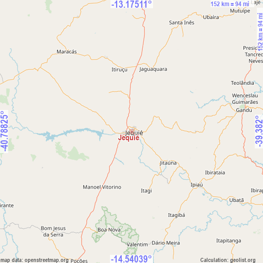
Jequié GPS coordinates[2]
13° 51' 31.5" South, 40° 5' 6.432" West
| Map corner | latitude | longitude |
|---|---|---|
| Upper-left | -13.17511°, | -40.78825° |
| Center: | -13.85875°, | -40.08512° |
| Lower-right: | -14.54039°, | -39.382° |
| Map W x H: | 151.8×151.8 km | = 94.3×94.3mi |
| max Lat: | 2.81972° ⇑41.5% North |
| Jequié: | -13.85875° |
| min Lat: | ⇓58.5% South -33.69111° |
| min Long | Jequié | max Long |
| -72.89583° | -40.08512° | -32.41083° |
| W 75.1%⇐ | ⇒24.9% E |
Elevation
Elevation of Jequié is 223 m = 732 ft, and this is 157.9 m = 518 ft below average elevation for this country.
| Max E: |
1603 m = 5259 ft | 59.1% |
| Avg. | 380.9 m = 1250 ft | |
| Jequié | 223 m = 732 ft | |
Min E: |
0 m = 0 ft | 40.9% |
See also: Jequié elevation on elevation.city.
Geographical zone
Jequié is located in South Torrid zone (between Equator and Tropic of Capricorn). Distance of this Southern Tropic circle is 1065 km =661.8 mi to South.| Distance of | km | miles | from Jequié |
|---|---|---|---|
| Equator | 1540.9 | 957.5 | to North |
| Tropic Capricorn | 1065 | 661.8 | to South |
| Antarctic Circle | 5860.2 | 3641.4 | to South |
| South Pole | 8466.1 | 5260.6 | to South |


Nearby cities:
15 places around Jequié: (largest is in red/bold)
• Gandu
65.9 km =40.9 mi,  78°
78°
• Ibirapitanga
83.9 km =52.1 mi,  113°
113°
• Ibirataia
53.3 km =33.1 mi,  115°
115°
• Ipiaú
48.3 km =30 mi,  129°
129°
• Itagi
34.9 km =21.7 mi,  165°
165°
• Itagibá
54 km =33.6 mi,  151°
151°
• Itiruçu
37 km =23 mi,  349°
349°
• Jaguaquara
38.5 km =23.9 mi,  18°
18°
• Jitaúna
26.4 km =16.4 mi, 130°
• Maracás
59.6 km =37 mi,  321°
321°
• Mutuípe
94 km =58.4 mi,  41°
41°
• Poções
80.5 km =50 mi,  202°
202°
• Santa Inês
69.3 km =43.1 mi, 24°
• Ubatã
71.8 km =44.6 mi, 122°
• Ubaíra
80 km =49.7 mi,  34°
34°
Sources, notices
• [Note1] Compared only with cities in Brazil existing in our database
• [Src1] Map data: © OpenStreetMap contributors (CC-BY-SA)
• [Src2] Other city data from geonames.org with taken over terms of usage.
• [Src3] Geographical zone / Annual Mean Temperature by Robert A. Rohde @ Wikipedia
