Ubatã geodata
Ubatã (Bahia) is a populated place; located in Brazil in America/Bahia (GMT-3) time zone. With population of 15,604 people, there are 1180 cities with bigger population in this country. Compared to other cities in Brazil, 57.8% of cities are located further ↓South; 77.3% of cities are located further ←West and 71.4% of cities have higher elevation than Ubatã. Note1


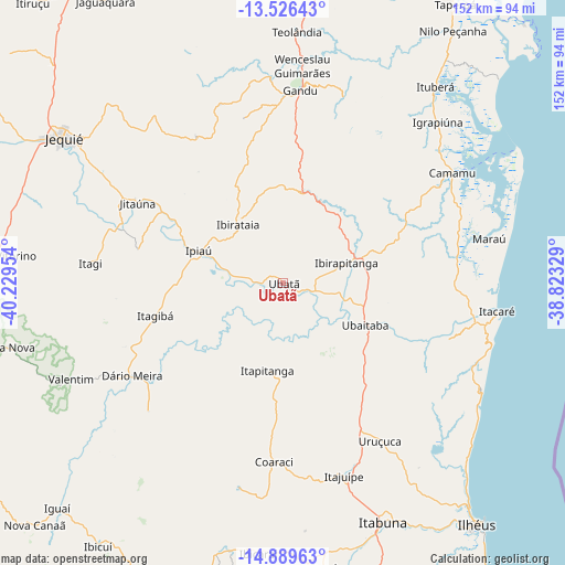
Ubatã GPS coordinates[2]
14° 12' 32.616" South, 39° 31' 35.076" West
| Map corner | latitude | longitude |
|---|---|---|
| Upper-left | -13.52643°, | -40.22954° |
| Center: | -14.20906°, | -39.52641° |
| Lower-right: | -14.88963°, | -38.82329° |
| Map W x H: | 151.6×151.6 km | = 94.2×94.2mi |
| max Lat: | 2.81972° ⇑42.2% North |
| Ubatã: | -14.20906° |
| min Lat: | ⇓57.8% South -33.69111° |
| min Long | Ubatã | max Long |
| -72.89583° | -39.52641° | -32.41083° |
| W 77.3%⇐ | ⇒22.7% E |
Elevation
Elevation of Ubatã is 112 m = 367 ft, and this is 268.9 m = 882 ft below average elevation for this country.
| Max E: |
1603 m = 5259 ft | 71.4% |
| Avg. | 380.9 m = 1250 ft | |
| Ubatã | 112 m = 367 ft | |
Min E: |
0 m = 0 ft | 28.6% |
See also: Brazil elevation on elevation.city.
Geographical zone
Ubatã is located in South Torrid zone (between Equator and Tropic of Capricorn). Distance of this Southern Tropic circle is 1026 km =637.5 mi to South.| Distance of | km | miles | from Ubatã |
|---|---|---|---|
| Equator | 1579.9 | 981.7 | to North |
| Tropic Capricorn | 1026 | 637.5 | to South |
| Antarctic Circle | 5821.3 | 3617.2 | to South |
| South Pole | 8427.2 | 5236.4 | to South |


Nearby cities:
15 places around Ubatã: (largest is in red/bold)
• Camamu
54.2 km =33.7 mi,  57°
57°
• Coaraci
48.1 km =29.9 mi,  183°
183°
• Gandu
51.9 km =32.2 mi,  4°
4°
• Ibirapitanga
17.2 km =10.7 mi,  73°
73°
• Ibirataia
20 km =12.4 mi,  322°
322°
• Ipiaú
24.4 km =15.2 mi,  289°
289°
• Itacaré
57.7 km =35.9 mi,  97°
97°
• Itagi
52 km =32.3 mi,  275°
275°
• Itagibá
35.1 km =21.8 mi,  256°
256°
• Itajuípe
54.6 km =33.9 mi,  162°
162°
• Ituberá
66.7 km =41.4 mi,  37°
37°
• Jitaúna
45.7 km =28.4 mi,  298°
298°
• Maraú
56.4 km =35 mi,  78°
78°
• Ubaitaba
24.7 km =15.3 mi,  117°
117°
• Uruçuca
50 km =31.1 mi,  148°
148°
Sources, notices
• [Note1] Compared only with cities in Brazil existing in our database
• [Src1] Map data: © OpenStreetMap contributors (CC-BY-SA)
• [Src2] Other city data from geonames.org with taken over terms of usage.
• [Src3] Geographical zone / Annual Mean Temperature by Robert A. Rohde @ Wikipedia
