Itabaianinha geodata
Itabaianinha (Sergipe) is a populated place; located in Brazil in America/Maceio (GMT-3) time zone. With population of 17,149 people, there are 1089 cities with bigger population in this country. Compared to other cities in Brazil, 64.2% of cities are located further ↓South; 85.3% of cities are located further ←West and 59.1% of cities have higher elevation than Itabaianinha. Note1


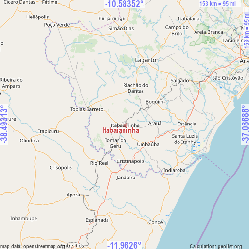
Itabaianinha GPS coordinates[2]
11° 16' 26.004" South, 37° 47' 24" West
| Map corner | latitude | longitude |
|---|---|---|
| Upper-left | -10.58352°, | -38.49313° |
| Center: | -11.27389°, | -37.79° |
| Lower-right: | -11.9626°, | -37.08688° |
| Map W x H: | 153.3×153.3 km | = 95.3×95.3mi |
| max Lat: | 2.81972° ⇑35.8% North |
| Itabaianinha: | -11.27389° |
| min Lat: | ⇓64.2% South -33.69111° |
| min Long | Itabaianinha | max Long |
| -72.89583° | -37.79° | -32.41083° |
| W 85.3%⇐ | ⇒14.7% E |
Elevation
Elevation of Itabaianinha is 223 m = 732 ft, and this is 157.9 m = 518 ft below average elevation for this country.
| Max E: |
1603 m = 5259 ft | 59.1% |
| Avg. | 380.9 m = 1250 ft | |
| Itabaianinha | 223 m = 732 ft | |
Min E: |
0 m = 0 ft | 40.9% |
See also: Brazil elevation on elevation.city.
Geographical zone
Itabaianinha is located in South Torrid zone (between Equator and Tropic of Capricorn). Distance of Equator is 1253.5 km =778.9 mi to North.| Distance of | km | miles | from Itabaianinha |
|---|---|---|---|
| Equator | 1253.5 | 778.9 | to North |
| Tropic Capricorn | 1352.4 | 840.3 | to South |
| Antarctic Circle | 6147.6 | 3819.9 | to South |
| South Pole | 8753.5 | 5439.2 | to South |


Nearby cities:
15 places around Itabaianinha: (largest is in red/bold)
• Acajutiba
49.8 km =30.9 mi,  209°
209°
• Arauá
18.6 km =11.6 mi,  86°
86°
• Boquim
23.3 km =14.5 mi,  52°
52°
• Cristinápolis
22.7 km =14.1 mi,  170°
170°
• Estância
38.4 km =23.9 mi, 89°
• Indiaroba
40.8 km =25.4 mi,  131°
131°
• Itapicuru
48.6 km =30.2 mi,  264°
264°
• Lagarto
42.5 km =26.4 mi,  21°
21°
• Riachão do Dantas
23.9 km =14.9 mi, 17°
• Rio Real
28.1 km =17.5 mi, 213°
• Salgado
43.6 km =27.1 mi, 51°
• Simão Dias
59.6 km =37 mi,  357°
357°
• Tobias Barreto
24.8 km =15.4 mi,  293°
293°
• Tomar do Geru
12.4 km =7.7 mi, 206°
• Umbaúba
18.9 km =11.7 mi, 130°
Sources, notices
• [Note1] Compared only with cities in Brazil existing in our database
• [Src1] Map data: © OpenStreetMap contributors (CC-BY-SA)
• [Src2] Other city data from geonames.org with taken over terms of usage.
• [Src3] Geographical zone / Annual Mean Temperature by Robert A. Rohde @ Wikipedia
