Salgado geodata
Salgado (Sergipe) is a populated place; located in Brazil in America/Maceio (GMT-3) time zone. With population of 5,457 people, there are 1899 cities with bigger population in this country. Compared to other cities in Brazil, 64.8% of cities are located further ↓South; 86.9% of cities are located further ←West and 72.1% of cities have higher elevation than Salgado. Note1


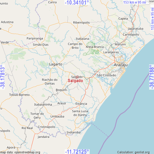
Salgado GPS coordinates[2]
11° 1' 54.984" South, 37° 28' 30" West
| Map corner | latitude | longitude |
|---|---|---|
| Upper-left | -10.34101°, | -38.17813° |
| Center: | -11.03194°, | -37.475° |
| Lower-right: | -11.72125°, | -36.77188° |
| Map W x H: | 153.5×153.5 km | = 95.4×95.4mi |
| max Lat: | 2.81972° ⇑35.2% North |
| Salgado: | -11.03194° |
| min Lat: | ⇓64.8% South -33.69111° |
| min Long | Salgado | max Long |
| -72.89583° | -37.475° | -32.41083° |
| W 86.9%⇐ | ⇒13.1% E |
Elevation
Elevation of Salgado is 103 m = 338 ft, and this is 277.9 m = 912 ft below average elevation for this country.
| Max E: |
1603 m = 5259 ft | 72.1% |
| Avg. | 380.9 m = 1250 ft | |
| Salgado | 103 m = 338 ft | |
Min E: |
0 m = 0 ft | 27.9% |
See also: Brazil elevation on elevation.city.
Geographical zone
Salgado is located in South Torrid zone (between Equator and Tropic of Capricorn). Distance of Equator is 1226.6 km =762.2 mi to North.| Distance of | km | miles | from Salgado |
|---|---|---|---|
| Equator | 1226.6 | 762.2 | to North |
| Tropic Capricorn | 1379.3 | 857.1 | to South |
| Antarctic Circle | 6174.5 | 3836.7 | to South |
| South Pole | 8780.4 | 5455.9 | to South |


Nearby cities:
15 places around Salgado: (largest is in red/bold)
• Aracaju
46 km =28.6 mi,  73°
73°
• Arauá
30.1 km =18.7 mi,  211°
211°
• Areia Branca
35.1 km =21.8 mi,  29°
29°
• Boquim
20.4 km =12.7 mi,  231°
231°
• Campo do Brito
33.3 km =20.7 mi,  356°
356°
• Estância
26.6 km =16.5 mi,  171°
171°
• Itabaiana
39 km =24.2 mi,  8°
8°
• Itabaianinha
43.6 km =27.1 mi, 231°
• Lagarto
23 km =14.3 mi,  303°
303°
• Laranjeiras
41.7 km =25.9 mi,  53°
53°
• Malhador
45.6 km =28.3 mi,  24°
24°
• Nossa Senhora do Socorro
42.9 km =26.7 mi,  62°
62°
• Riachão do Dantas
27.6 km =17.1 mi,  261°
261°
• São Cristóvão
29.4 km =18.3 mi,  86°
86°
• Umbaúba
43.9 km =27.3 mi, 207°
Sources, notices
• [Note1] Compared only with cities in Brazil existing in our database
• [Src1] Map data: © OpenStreetMap contributors (CC-BY-SA)
• [Src2] Other city data from geonames.org with taken over terms of usage.
• [Src3] Geographical zone / Annual Mean Temperature by Robert A. Rohde @ Wikipedia
