Umbaúba geodata
Umbaúba (Sergipe) is a populated place; located in Brazil in America/Maceio (GMT-3) time zone. With population of 12,880 people, there are 1379 cities with bigger population in this country. Compared to other cities in Brazil, 63.8% of cities are located further ↓South; 85.9% of cities are located further ←West and 68.1% of cities have higher elevation than Umbaúba. Note1


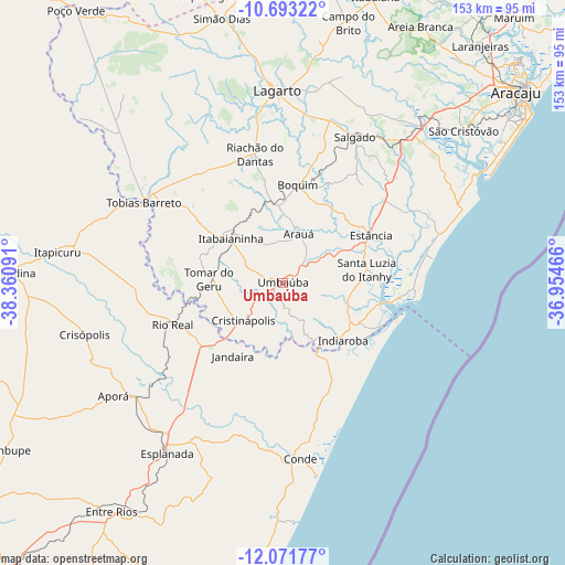
Umbaúba GPS coordinates[2]
11° 22' 59.988" South, 37° 39' 28.008" West
| Map corner | latitude | longitude |
|---|---|---|
| Upper-left | -10.69322°, | -38.36091° |
| Center: | -11.38333°, | -37.65778° |
| Lower-right: | -12.07177°, | -36.95466° |
| Map W x H: | 153.3×153.3 km | = 95.3×95.3mi |
| max Lat: | 2.81972° ⇑36.2% North |
| Umbaúba: | -11.38333° |
| min Lat: | ⇓63.8% South -33.69111° |
| min Long | Umbaúba | max Long |
| -72.89583° | -37.65778° | -32.41083° |
| W 85.9%⇐ | ⇒14.1% E |
Elevation
Elevation of Umbaúba is 142 m = 466 ft, and this is 238.9 m = 784 ft below average elevation for this country.
| Max E: |
1603 m = 5259 ft | 68.1% |
| Avg. | 380.9 m = 1250 ft | |
| Umbaúba | 142 m = 466 ft | |
Min E: |
0 m = 0 ft | 31.9% |
See also: Brazil elevation on elevation.city.
Geographical zone
Umbaúba is located in South Torrid zone (between Equator and Tropic of Capricorn). Distance of Equator is 1265.7 km =786.5 mi to North.| Distance of | km | miles | from Umbaúba |
|---|---|---|---|
| Equator | 1265.7 | 786.5 | to North |
| Tropic Capricorn | 1340.2 | 832.8 | to South |
| Antarctic Circle | 6135.5 | 3812.4 | to South |
| South Pole | 8741.4 | 5431.7 | to South |


Nearby cities:
15 places around Umbaúba: (largest is in red/bold)
• Acajutiba
50 km =31.1 mi,  231°
231°
• Arauá
14.1 km =8.8 mi,  17°
17°
• Boquim
26.6 km =16.5 mi,  8°
8°
• Conde
48.1 km =29.9 mi,  173°
173°
• Cristinápolis
14.8 km =9.2 mi, 226°
• Esplanada
55.5 km =34.5 mi,  214°
214°
• Estância
27.1 km =16.8 mi,  61°
61°
• Indiaroba
21.9 km =13.6 mi,  133°
133°
• Itabaianinha
18.9 km =11.7 mi,  310°
310°
• Lagarto
51.8 km =32.2 mi,  0°
0°
• Riachão do Dantas
35.7 km =22.2 mi,  348°
348°
• Rio Real
32 km =19.9 mi,  249°
249°
• Salgado
43.9 km =27.3 mi,  27°
27°
• Tobias Barreto
43.3 km =26.9 mi,  300°
300°
• Tomar do Geru
20 km =12.4 mi,  273°
273°
Sources, notices
• [Note1] Compared only with cities in Brazil existing in our database
• [Src1] Map data: © OpenStreetMap contributors (CC-BY-SA)
• [Src2] Other city data from geonames.org with taken over terms of usage.
• [Src3] Geographical zone / Annual Mean Temperature by Robert A. Rohde @ Wikipedia
