Lagarto geodata
Lagarto (Sergipe) is a populated place; located in Brazil in America/Maceio (GMT-3) time zone. With population of 45,445 people, there are 468 cities with bigger population in this country. Compared to other cities in Brazil, 65.1% of cities are located further ↓South; 86% of cities are located further ←West and 68.3% of cities have higher elevation than Lagarto. Note1


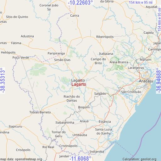
Lagarto GPS coordinates[2]
10° 55' 1.992" South, 37° 39' 0" West
| Map corner | latitude | longitude |
|---|---|---|
| Upper-left | -10.22603°, | -38.35313° |
| Center: | -10.91722°, | -37.65° |
| Lower-right: | -11.6068°, | -36.94688° |
| Map W x H: | 153.5×153.5 km | = 95.4×95.4mi |
| max Lat: | 2.81972° ⇑34.9% North |
| Lagarto: | -10.91722° |
| min Lat: | ⇓65.1% South -33.69111° |
| min Long | Lagarto | max Long |
| -72.89583° | -37.65° | -32.41083° |
| W 86%⇐ | ⇒14% E |
Elevation
Elevation of Lagarto is 138 m = 453 ft, and this is 242.9 m = 797 ft below average elevation for this country.
| Max E: |
1603 m = 5259 ft | 68.3% |
| Avg. | 380.9 m = 1250 ft | |
| Lagarto | 138 m = 453 ft | |
Min E: |
0 m = 0 ft | 31.7% |
See also: Lagarto elevation on elevation.city.
Geographical zone
Lagarto is located in South Torrid zone (between Equator and Tropic of Capricorn). Distance of Equator is 1213.9 km =754.3 mi to North.| Distance of | km | miles | from Lagarto |
|---|---|---|---|
| Equator | 1213.9 | 754.3 | to North |
| Tropic Capricorn | 1392 | 864.9 | to South |
| Antarctic Circle | 6187.3 | 3844.6 | to South |
| South Pole | 8793.2 | 5463.8 | to South |


Nearby cities:
15 places around Lagarto: (largest is in red/bold)
• Arauá
38.5 km =23.9 mi,  175°
175°
• Areia Branca
40.6 km =25.2 mi,  64°
64°
• Boquim
25.7 km =16 mi,  172°
172°
• Campo do Brito
26.7 km =16.6 mi,  39°
39°
• Estância
45.4 km =28.2 mi,  149°
149°
• Frei Paulo
42.8 km =26.6 mi,  17°
17°
• Itabaiana
35.6 km =22.1 mi, 43°
• Itabaianinha
42.5 km =26.4 mi,  201°
201°
• Malhador
47.5 km =29.5 mi,  52°
52°
• Paripiranga
34.5 km =21.4 mi,  317°
317°
• Riachão do Dantas
18.7 km =11.6 mi,  205°
205°
• Ribeirópolis
49.1 km =30.5 mi,  31°
31°
• Salgado
23 km =14.3 mi,  123°
123°
• Simão Dias
26.6 km =16.5 mi, 318°
• Tobias Barreto
48.2 km =30 mi,  232°
232°
Sources, notices
• [Note1] Compared only with cities in Brazil existing in our database
• [Src1] Map data: © OpenStreetMap contributors (CC-BY-SA)
• [Src2] Other city data from geonames.org with taken over terms of usage.
• [Src3] Geographical zone / Annual Mean Temperature by Robert A. Rohde @ Wikipedia
