Arauá geodata
Arauá (Sergipe) is a populated place; located in Brazil in America/Maceio (GMT-3) time zone. With population of 4,747 people, there are 1931 cities with bigger population in this country. Compared to other cities in Brazil, 64.3% of cities are located further ↓South; 86.3% of cities are located further ←West and 71.4% of cities have higher elevation than Arauá. Note1


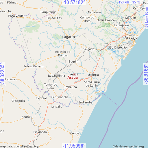
Arauá GPS coordinates[2]
11° 15' 43.992" South, 37° 37' 10.992" West
| Map corner | latitude | longitude |
|---|---|---|
| Upper-left | -10.57182°, | -38.32285° |
| Center: | -11.26222°, | -37.61972° |
| Lower-right: | -11.95096°, | -36.9166° |
| Map W x H: | 153.3×153.3 km | = 95.3×95.3mi |
| max Lat: | 2.81972° ⇑35.7% North |
| Arauá: | -11.26222° |
| min Lat: | ⇓64.3% South -33.69111° |
| min Long | Arauá | max Long |
| -72.89583° | -37.61972° | -32.41083° |
| W 86.3%⇐ | ⇒13.7% E |
Elevation
Elevation of Arauá is 112 m = 367 ft, and this is 268.9 m = 882 ft below average elevation for this country.
| Max E: |
1603 m = 5259 ft | 71.4% |
| Avg. | 380.9 m = 1250 ft | |
| Arauá | 112 m = 367 ft | |
Min E: |
0 m = 0 ft | 28.6% |
See also: Brazil elevation on elevation.city.
Geographical zone
Arauá is located in South Torrid zone (between Equator and Tropic of Capricorn). Distance of Equator is 1252.2 km =778.1 mi to North.| Distance of | km | miles | from Arauá |
|---|---|---|---|
| Equator | 1252.2 | 778.1 | to North |
| Tropic Capricorn | 1353.7 | 841.1 | to South |
| Antarctic Circle | 6148.9 | 3820.7 | to South |
| South Pole | 8754.8 | 5440 | to South |


Nearby cities:
15 places around Arauá: (largest is in red/bold)
• Boquim
12.8 km =8 mi,  359°
359°
• Campo do Brito
60.4 km =37.5 mi,  13°
13°
• Conde
61.3 km =38.1 mi,  179°
179°
• Cristinápolis
27.9 km =17.3 mi,  211°
211°
• Estância
19.8 km =12.3 mi,  91°
91°
• Indiaroba
30.9 km =19.2 mi,  157°
157°
• Itabaianinha
18.6 km =11.6 mi,  266°
266°
• Lagarto
38.5 km =23.9 mi, 355°
• Riachão do Dantas
24.4 km =15.2 mi,  331°
331°
• Rio Real
42.1 km =26.2 mi,  234°
234°
• Salgado
30.1 km =18.7 mi,  31°
31°
• São Cristóvão
52.8 km =32.8 mi,  58°
58°
• Tobias Barreto
42.2 km =26.2 mi,  281°
281°
• Tomar do Geru
27.1 km =16.8 mi,  242°
242°
• Umbaúba
14.1 km =8.8 mi,  197°
197°
Sources, notices
• [Note1] Compared only with cities in Brazil existing in our database
• [Src1] Map data: © OpenStreetMap contributors (CC-BY-SA)
• [Src2] Other city data from geonames.org with taken over terms of usage.
• [Src3] Geographical zone / Annual Mean Temperature by Robert A. Rohde @ Wikipedia
