Iconha geodata
Iconha (Espírito Santo) is a populated place; located in Brazil in America/Sao_Paulo (GMT-3) time zone. With population of 5,051 people, there are 1911 cities with bigger population in this country. Compared to other cities in Brazil, 61.8% of cities are located further ↑North; 71.1% of cities are located further ←West and 85.7% of cities have higher elevation than Iconha. Note1


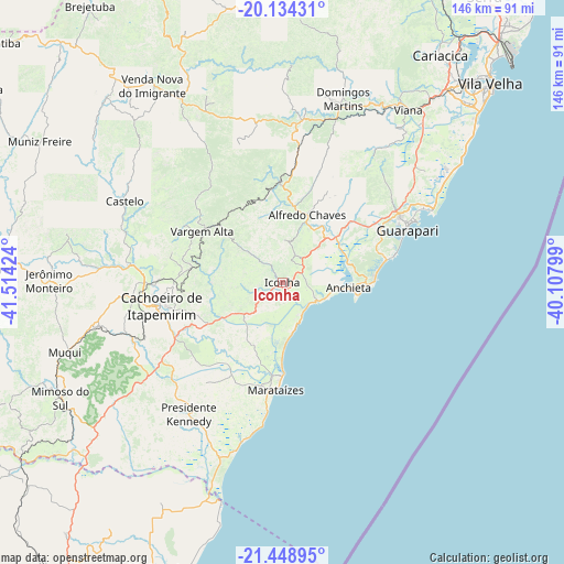
Iconha GPS coordinates[2]
20° 47' 35.016" South, 40° 48' 39.996" West
| Map corner | latitude | longitude |
|---|---|---|
| Upper-left | -20.13431°, | -41.51424° |
| Center: | -20.79306°, | -40.81111° |
| Lower-right: | -21.44895°, | -40.10799° |
| Map W x H: | 146.2×146.2 km | = 90.8×90.8mi |
| max Lat: | 2.81972° ⇑61.8% North |
| Iconha: | -20.79306° |
| min Lat: | ⇓38.2% South -33.69111° |
| min Long | Iconha | max Long |
| -72.89583° | -40.81111° | -32.41083° |
| W 71.1%⇐ | ⇒28.9% E |
Elevation
Elevation of Iconha is 29 m = 95 ft, and this is 351.9 m = 1155 ft below average elevation for this country.
| Max E: |
1603 m = 5259 ft | 85.7% |
| Avg. | 380.9 m = 1250 ft | |
| Iconha | 29 m = 95 ft | |
Min E: |
0 m = 0 ft | 14.3% |
See also: Brazil elevation on elevation.city.
Geographical zone
Iconha is located in South Torrid zone (between Equator and Tropic of Capricorn). Distance of this Southern Tropic circle is 293.9 km =182.6 mi to South.| Distance of | km | miles | from Iconha |
|---|---|---|---|
| Equator | 2312 | 1436.6 | to North |
| Tropic Capricorn | 293.9 | 182.6 | to South |
| Antarctic Circle | 5089.2 | 3162.3 | to South |
| South Pole | 7695.1 | 4781.5 | to South |


Nearby cities:
15 places around Iconha: (largest is in red/bold)
• Alfredo Chaves
18.7 km =11.6 mi,  19°
19°
• Cachoeiro de Itapemirim
32 km =19.9 mi,  258°
258°
• Castelo
44.2 km =27.5 mi,  298°
298°
• Conceição do Castelo
65.3 km =40.6 mi,  316°
316°
• Domingos Martins
50.3 km =31.3 mi, 18°
• Guarapari
34.9 km =21.7 mi,  67°
67°
• Itapemirim
24.4 km =15.2 mi,  185°
185°
• Jerônimo Monteiro
60.7 km =37.7 mi,  270°
270°
• Marataizes
27.9 km =17.3 mi,  182°
182°
• Marechal Floriano
44.3 km =27.5 mi, 17°
• Mimoso do Sul
65.1 km =40.5 mi,  242°
242°
• Piúma
10.5 km =6.5 mi,  118°
118°
• Rio Novo do Sul
15.1 km =9.4 mi, 239°
• Vargem Alta
24.4 km =15.2 mi, 303°
• Viana
55.5 km =34.5 mi,  36°
36°
Sources, notices
• [Note1] Compared only with cities in Brazil existing in our database
• [Src1] Map data: © OpenStreetMap contributors (CC-BY-SA)
• [Src2] Other city data from geonames.org with taken over terms of usage.
• [Src3] Geographical zone / Annual Mean Temperature by Robert A. Rohde @ Wikipedia
