Alfredo Chaves geodata
Alfredo Chaves (Espírito Santo) is a populated place; located in Brazil in America/Sao_Paulo (GMT-3) time zone. With population of 6,422 people, there are 1862 cities with bigger population in this country. Compared to other cities in Brazil, 60.7% of cities are located further ↑North; 71.3% of cities are located further ←West and 89.5% of cities have higher elevation than Alfredo Chaves. Note1


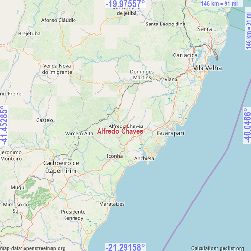
Alfredo Chaves GPS coordinates[2]
20° 38' 6" South, 40° 44' 58.992" West
| Map corner | latitude | longitude |
|---|---|---|
| Upper-left | -19.97557°, | -41.45285° |
| Center: | -20.635°, | -40.74972° |
| Lower-right: | -21.29158°, | -40.0466° |
| Map W x H: | 146.3×146.3 km | = 90.9×90.9mi |
| max Lat: | 2.81972° ⇑60.7% North |
| Alfredo Chaves: | -20.635° |
| min Lat: | ⇓39.3% South -33.69111° |
| min Long | Alfredo Chaves | max Long |
| -72.89583° | -40.74972° | -32.41083° |
| W 71.3%⇐ | ⇒28.7% E |
Elevation
Elevation of Alfredo Chaves is 19 m = 62 ft, and this is 361.9 m = 1187 ft below average elevation for this country.
| Max E: |
1603 m = 5259 ft | 89.5% |
| Avg. | 380.9 m = 1250 ft | |
| Alfredo Chaves | 19 m = 62 ft | |
Min E: |
0 m = 0 ft | 10.5% |
See also: Brazil elevation on elevation.city.
Geographical zone
Alfredo Chaves is located in South Torrid zone (between Equator and Tropic of Capricorn). Distance of this Southern Tropic circle is 311.5 km =193.6 mi to South.| Distance of | km | miles | from Alfredo Chaves |
|---|---|---|---|
| Equator | 2294.4 | 1425.7 | to North |
| Tropic Capricorn | 311.5 | 193.6 | to South |
| Antarctic Circle | 5106.8 | 3173.2 | to South |
| South Pole | 7712.7 | 4792.4 | to South |


Nearby cities:
15 places around Alfredo Chaves: (largest is in red/bold)
• Cachoeiro de Itapemirim
44.6 km =27.7 mi,  237°
237°
• Castelo
45.4 km =28.2 mi,  274°
274°
• Conceição do Castelo
59.4 km =36.9 mi,  299°
299°
• Domingos Martins
31.6 km =19.6 mi,  17°
17°
• Guarapari
26.1 km =16.2 mi,  99°
99°
• Iconha
18.7 km =11.6 mi,  199°
199°
• Itapemirim
42.7 km =26.5 mi,  191°
191°
• Marataizes
46.1 km =28.6 mi, 189°
• Marechal Floriano
25.7 km =16 mi, 15°
• Piúma
22.7 km =14.1 mi,  172°
172°
• Rio Novo do Sul
31.9 km =19.8 mi,  217°
217°
• Vargem Alta
27.1 km =16.8 mi,  261°
261°
• Viana
37.9 km =23.5 mi,  44°
44°
• Vila Velha
58.5 km =36.4 mi,  54°
54°
• Vitória
55.4 km =34.4 mi, 50°
Sources, notices
• [Note1] Compared only with cities in Brazil existing in our database
• [Src1] Map data: © OpenStreetMap contributors (CC-BY-SA)
• [Src2] Other city data from geonames.org with taken over terms of usage.
• [Src3] Geographical zone / Annual Mean Temperature by Robert A. Rohde @ Wikipedia
