Castelo geodata
Castelo (Espírito Santo) is a populated place; located in Brazil in America/Sao_Paulo (GMT-3) time zone. With population of 20,198 people, there are 930 cities with bigger population in this country. Compared to other cities in Brazil, 60.5% of cities are located further ↑North; 69.3% of cities are located further ←West and 69.4% of cities have higher elevation than Castelo. Note1


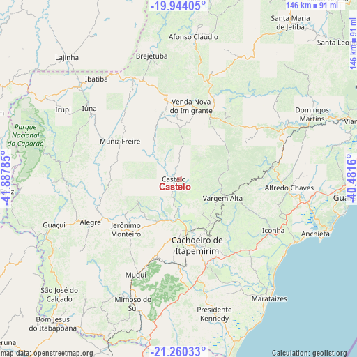
Castelo GPS coordinates[2]
20° 36' 12.996" South, 41° 11' 4.992" West
| Map corner | latitude | longitude |
|---|---|---|
| Upper-left | -19.94405°, | -41.88785° |
| Center: | -20.60361°, | -41.18472° |
| Lower-right: | -21.26033°, | -40.4816° |
| Map W x H: | 146.4×146.4 km | = 91×91mi |
| max Lat: | 2.81972° ⇑60.5% North |
| Castelo: | -20.60361° |
| min Lat: | ⇓39.5% South -33.69111° |
| min Long | Castelo | max Long |
| -72.89583° | -41.18472° | -32.41083° |
| W 69.3%⇐ | ⇒30.7% E |
Elevation
Elevation of Castelo is 129 m = 423 ft, and this is 251.9 m = 826 ft below average elevation for this country.
| Max E: |
1603 m = 5259 ft | 69.4% |
| Avg. | 380.9 m = 1250 ft | |
| Castelo | 129 m = 423 ft | |
Min E: |
0 m = 0 ft | 30.6% |
See also: Brazil elevation on elevation.city.
Geographical zone
Castelo is located in South Torrid zone (between Equator and Tropic of Capricorn). Distance of this Southern Tropic circle is 315 km =195.7 mi to South.| Distance of | km | miles | from Castelo |
|---|---|---|---|
| Equator | 2290.9 | 1423.5 | to North |
| Tropic Capricorn | 315 | 195.7 | to South |
| Antarctic Circle | 5110.3 | 3175.4 | to South |
| South Pole | 7716.2 | 4794.6 | to South |


Nearby cities:
15 places around Castelo: (largest is in red/bold)
• Alegre
40.4 km =25.1 mi,  243°
243°
• Alfredo Chaves
45.4 km =28.2 mi,  94°
94°
• Cachoeiro de Itapemirim
28.3 km =17.6 mi,  164°
164°
• Conceição do Castelo
26.9 km =16.7 mi,  346°
346°
• Guaçuí
54.9 km =34.1 mi,  249°
249°
• Ibatiba
53.3 km =33.1 mi,  320°
320°
• Iconha
44.2 km =27.5 mi,  118°
118°
• Irupi
55.5 km =34.5 mi,  301°
301°
• Iúna
46.5 km =28.9 mi,  308°
308°
• Jerônimo Monteiro
30.1 km =18.7 mi,  226°
226°
• Mimoso do Sul
54.6 km =33.9 mi,  200°
200°
• Muniz Freire
28.4 km =17.6 mi, 303°
• Piúma
54.7 km =34 mi, 118°
• Rio Novo do Sul
38.7 km =24 mi,  138°
138°
• Vargem Alta
20 km =12.4 mi,  112°
112°
Sources, notices
• [Note1] Compared only with cities in Brazil existing in our database
• [Src1] Map data: © OpenStreetMap contributors (CC-BY-SA)
• [Src2] Other city data from geonames.org with taken over terms of usage.
• [Src3] Geographical zone / Annual Mean Temperature by Robert A. Rohde @ Wikipedia
