Guarapari geodata
Guarapari (Espírito Santo) is a populated place; located in Brazil in America/Sao_Paulo (GMT-3) time zone. With population of 100,925 people, there are 227 cities with bigger population in this country. Compared to other cities in Brazil, 61% of cities are located further ↑North; 72.5% of cities are located further ←West and 99% of cities have higher elevation than Guarapari. Note1


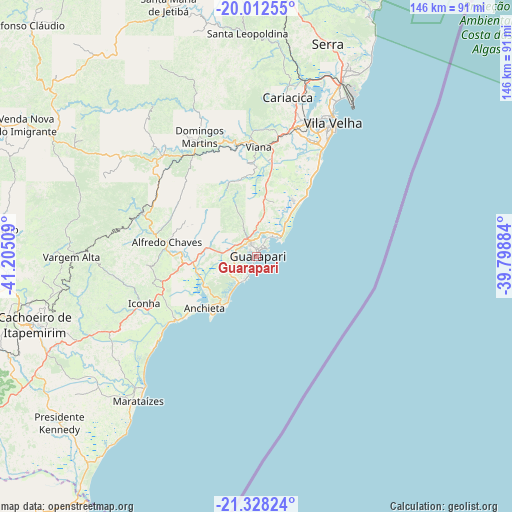
Guarapari GPS coordinates[2]
20° 40' 18.552" South, 40° 30' 7.056" West
| Map corner | latitude | longitude |
|---|---|---|
| Upper-left | -20.01255°, | -41.20509° |
| Center: | -20.67182°, | -40.50196° |
| Lower-right: | -21.32824°, | -39.79884° |
| Map W x H: | 146.3×146.3 km | = 90.9×90.9mi |
| max Lat: | 2.81972° ⇑61% North |
| Guarapari: | -20.67182° |
| min Lat: | ⇓39% South -33.69111° |
| min Long | Guarapari | max Long |
| -72.89583° | -40.50196° | -32.41083° |
| W 72.5%⇐ | ⇒27.5% E |
Elevation
Elevation of Guarapari is 5 m = 16 ft, and this is 375.9 m = 1233 ft below average elevation for this country.
| Max E: |
1603 m = 5259 ft | 99% |
| Avg. | 380.9 m = 1250 ft | |
| Guarapari | 5 m = 16 ft | |
Min E: |
0 m = 0 ft | 1% |
See also: Guarapari elevation on elevation.city.
Geographical zone
Guarapari is located in South Torrid zone (between Equator and Tropic of Capricorn). Distance of this Southern Tropic circle is 307.4 km =191 mi to South.| Distance of | km | miles | from Guarapari |
|---|---|---|---|
| Equator | 2298.5 | 1428.2 | to North |
| Tropic Capricorn | 307.4 | 191 | to South |
| Antarctic Circle | 5102.7 | 3170.7 | to South |
| South Pole | 7708.6 | 4789.9 | to South |


Nearby cities:
15 places around Guarapari: (largest is in red/bold)
• Alfredo Chaves
26.1 km =16.2 mi,  279°
279°
• Cachoeiro de Itapemirim
66.5 km =41.3 mi,  252°
252°
• Domingos Martins
38 km =23.6 mi,  334°
334°
• Iconha
34.9 km =21.7 mi, 247°
• Itapemirim
51.1 km =31.8 mi,  222°
222°
• Marataizes
53.2 km =33.1 mi, 219°
• Marechal Floriano
34.4 km =21.4 mi, 326°
• Piúma
29.4 km =18.3 mi,  231°
231°
• Rio Novo do Sul
49.9 km =31 mi,  244°
244°
• Santa Leopoldina
63.6 km =39.5 mi,  357°
357°
• Serra
63.7 km =39.6 mi,  18°
18°
• Vargem Alta
52.5 km =32.6 mi,  270°
270°
• Viana
31.3 km =19.4 mi,  1°
1°
• Vila Velha
43.8 km =27.2 mi,  29°
29°
• Vitória
42.7 km =26.5 mi, 23°
Sources, notices
• [Note1] Compared only with cities in Brazil existing in our database
• [Src1] Map data: © OpenStreetMap contributors (CC-BY-SA)
• [Src2] Other city data from geonames.org with taken over terms of usage.
• [Src3] Geographical zone / Annual Mean Temperature by Robert A. Rohde @ Wikipedia
