Ibiúna geodata
Ibiúna (São Paulo) is a seat of a second-order administrative division; located in Brazil in America/Sao_Paulo (GMT-3) time zone. With population of 22,860 people, there are 835 cities with bigger population in this country. Compared to other cities in Brazil, 84.1% of cities are located further ↑North; 60% of cities are located further →East and 93.3% of cities have lower elevation than Ibiúna. Note1


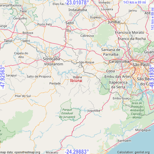
Ibiúna GPS coordinates[2]
23° 39' 23.004" South, 47° 13' 21" West
| Map corner | latitude | longitude |
|---|---|---|
| Upper-left | -23.01078°, | -47.92563° |
| Center: | -23.65639°, | -47.2225° |
| Lower-right: | -24.29883°, | -46.51938° |
| Map W x H: | 143.2×143.2 km | = 89×89mi |
| max Lat: | 2.81972° ⇑84.1% North |
| Ibiúna: | -23.65639° |
| min Lat: | ⇓15.9% South -33.69111° |
| min Long | Ibiúna | max Long |
| -72.89583° | -47.2225° | -32.41083° |
| W 40%⇐ | ⇒60% E |
Elevation
Elevation of Ibiúna is 868 m = 2848 ft, and this is 487.1 m = 1598 ft above average elevation for this country.
| Max E: |
1603 m = 5259 ft | 6.7% |
| Ibiúna | 868 m 2848 ft | |
| Avg. | 380.9 m = 1250 ft | |
Min E: |
0 m = 0 ft | 93.3% |
See also: Brazil elevation on elevation.city.
Geographical zone
Ibiúna is located in South temperate zone (between Tropic of Capricorn and the Antarctic Circle). Distance of this Southern Tropic circle is 24.4 km =15.2 mi to North.| Distance of | km | miles | from Ibiúna |
|---|---|---|---|
| Equator | 2630.3 | 1634.4 | to North |
| Tropic Capricorn | 24.4 | 15.2 | to North |
| Antarctic Circle | 4770.8 | 2964.4 | to South |
| South Pole | 7376.7 | 4583.7 | to South |


Nearby cities:
15 places around Ibiúna: (largest is in red/bold)
• Cotia
31.4 km =19.5 mi,  79°
79°
• Embu
37.7 km =23.4 mi,  88°
88°
• Itapecerica da Serra
38.6 km =24 mi,  100°
100°
• Itapevi
31.7 km =19.7 mi,  67°
67°
• Jandira
35.6 km =22.1 mi, 66°
• Juquitiba
34.4 km =21.4 mi,  152°
152°
• Mairinque
12.9 km =8 mi,  17°
17°
• Piedade
21.8 km =13.5 mi,  253°
253°
• Pirapora do Bom Jesus
36.6 km =22.7 mi,  37°
37°
• Salto de Pirapora
35.7 km =22.2 mi,  271°
271°
• Sorocaba
29.5 km =18.3 mi,  305°
305°
• São Lourenço da Serra
35.9 km =22.3 mi,  127°
127°
• São Roque
16.7 km =10.4 mi,  32°
32°
• Vargem Grande Paulista
20.8 km =12.9 mi, 73°
• Votorantim
25.1 km =15.6 mi,  299°
299°
Sources, notices
• [Note1] Compared only with cities in Brazil existing in our database
• [Src1] Map data: © OpenStreetMap contributors (CC-BY-SA)
• [Src2] Other city data from geonames.org with taken over terms of usage.
• [Src3] Geographical zone / Annual Mean Temperature by Robert A. Rohde @ Wikipedia
