Votorantim geodata
Votorantim (São Paulo) is a populated place; located in Brazil in America/Sao_Paulo (GMT-3) time zone. With population of 99,390 people, there are 232 cities with bigger population in this country. Compared to other cities in Brazil, 83.2% of cities are located further ↑North; 61.1% of cities are located further →East and 69.7% of cities have lower elevation than Votorantim. Note1


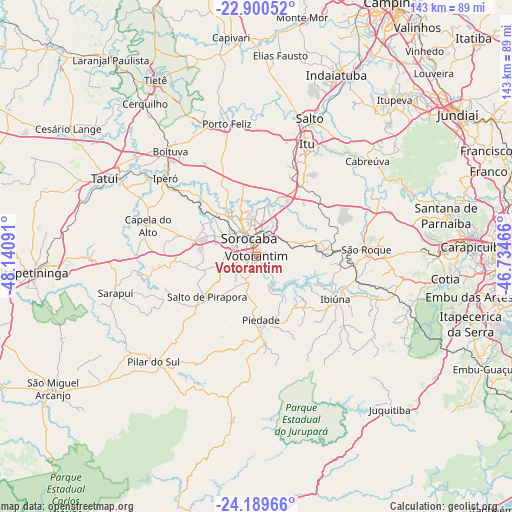
Votorantim GPS coordinates[2]
23° 32' 48.012" South, 47° 26' 16.008" West
| Map corner | latitude | longitude |
|---|---|---|
| Upper-left | -22.90052°, | -48.14091° |
| Center: | -23.54667°, | -47.43778° |
| Lower-right: | -24.18966°, | -46.73466° |
| Map W x H: | 143.3×143.3 km | = 89×89mi |
| max Lat: | 2.81972° ⇑83.2% North |
| Votorantim: | -23.54667° |
| min Lat: | ⇓16.8% South -33.69111° |
| min Long | Votorantim | max Long |
| -72.89583° | -47.43778° | -32.41083° |
| W 38.9%⇐ | ⇒61.1% E |
Elevation
Elevation of Votorantim is 572 m = 1877 ft, and this is 191.1 m = 627 ft above average elevation for this country.
| Max E: |
1603 m = 5259 ft | 30.3% |
| Votorantim | 572 m 1877 ft | |
| Avg. | 380.9 m = 1250 ft | |
Min E: |
0 m = 0 ft | 69.7% |
See also: Votorantim elevation on elevation.city.
Geographical zone
Votorantim is located in South temperate zone (between Tropic of Capricorn and the Antarctic Circle). Distance of this Southern Tropic circle is 12.2 km =7.6 mi to North.| Distance of | km | miles | from Votorantim |
|---|---|---|---|
| Equator | 2618.1 | 1626.8 | to North |
| Tropic Capricorn | 12.2 | 7.6 | to North |
| Antarctic Circle | 4783 | 2972 | to South |
| South Pole | 7388.9 | 4591.2 | to South |


Nearby cities:
15 places around Votorantim: (largest is in red/bold)
• Araçoiaba da Serra
18.6 km =11.6 mi,  284°
284°
• Boituva
37.8 km =23.5 mi,  320°
320°
• Cabreúva
40.9 km =25.4 mi,  49°
49°
• Capela do Alto
31.4 km =19.5 mi,  285°
285°
• Ibiúna
25.1 km =15.6 mi,  119°
119°
• Iperó
33.6 km =20.9 mi,  310°
310°
• Itu
34.4 km =21.4 mi,  24°
24°
• Mairinque
25.9 km =16.1 mi,  89°
89°
• Piedade
18.4 km =11.4 mi,  176°
176°
• Pilar do Sul
41 km =25.5 mi,  223°
223°
• Porto Feliz
37.9 km =23.5 mi,  346°
346°
• Salto
41.4 km =25.7 mi, 21°
• Salto de Pirapora
17.9 km =11.1 mi,  230°
230°
• Sorocaba
5.4 km =3.4 mi,  337°
337°
• São Roque
30.9 km =19.2 mi, 86°
Sources, notices
• [Note1] Compared only with cities in Brazil existing in our database
• [Src1] Map data: © OpenStreetMap contributors (CC-BY-SA)
• [Src2] Other city data from geonames.org with taken over terms of usage.
• [Src3] Geographical zone / Annual Mean Temperature by Robert A. Rohde @ Wikipedia
