Novo Horizonte geodata
Novo Horizonte (São Paulo) is a populated place; located in Brazil in America/Sao_Paulo (GMT-3) time zone. With population of 30,158 people, there are 669 cities with bigger population in this country. Compared to other cities in Brazil, 66.3% of cities are located further ↑North; 73.3% of cities are located further →East and 58.1% of cities have lower elevation than Novo Horizonte. Note1


Novo Horizonte GPS coordinates[2]
21° 28' 5.016" South, 49° 13' 14.988" West
| Map corner | latitude | longitude |
|---|---|---|
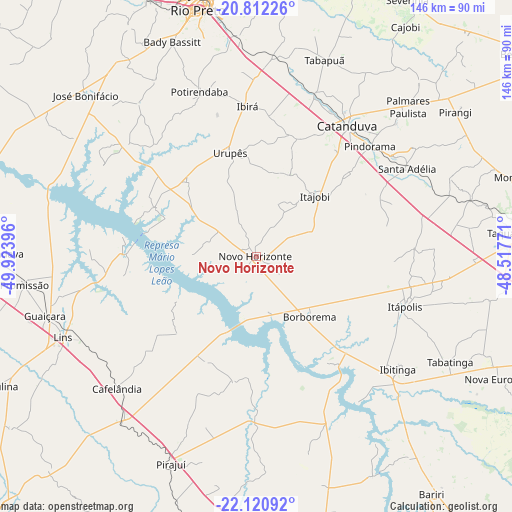
| Upper-left | -20.81226°, | -49.92396° |
| Center: | -21.46806°, | -49.22083° |
| Lower-right: | -22.12092°, | -48.51771° |
| Map W x H: | 145.5×145.5 km | = 90.4×90.4mi |
| max Lat: | 2.81972° ⇑66.3% North |
| Novo Horizonte: | -21.46806° |
| min Lat: | ⇓33.7% South -33.69111° |
| min Long | Novo Horizonte | max Long |
| -72.89583° | -49.22083° | -32.41083° |
| W 26.7%⇐ | ⇒73.3% E |
Elevation
Elevation of Novo Horizonte is 453 m = 1486 ft, and this is 72.1 m = 237 ft above average elevation for this country.
| Max E: |
1603 m = 5259 ft | 41.9% |
| Novo Horizonte | 453 m 1486 ft | |
| Avg. | 380.9 m = 1250 ft | |
Min E: |
0 m = 0 ft | 58.1% |
See also: Brazil elevation on elevation.city.
Geographical zone
Novo Horizonte is located in South Torrid zone (between Equator and Tropic of Capricorn). Distance of this Southern Tropic circle is 218.9 km =136 mi to South.| Distance of | km | miles | from Novo Horizonte |
|---|---|---|---|
| Equator | 2387 | 1483.2 | to North |
| Tropic Capricorn | 218.9 | 136 | to South |
| Antarctic Circle | 5014.1 | 3115.6 | to South |
| South Pole | 7620 | 4734.8 | to South |


Nearby cities:
15 places around Novo Horizonte: (largest is in red/bold)
• Bady Bassitt
65.4 km =40.6 mi,  339°
339°
• Borborema
22.7 km =14.1 mi,  137°
137°
• Cafelândia
54.8 km =34.1 mi,  227°
227°
• Catanduva
44.8 km =27.8 mi,  34°
34°
• Ibitinga
51.8 km =32.2 mi,  128°
128°
• Itajobi
24 km =14.9 mi,  45°
45°
• Itápolis
44.5 km =27.7 mi,  108°
108°
• José Bonifácio
66.9 km =41.6 mi,  313°
313°
• Lins
58.8 km =36.5 mi,  246°
246°
• Pindorama
45.2 km =28.1 mi, 45°
• Pirajuí
63.8 km =39.6 mi,  202°
202°
• Promissão
66.4 km =41.3 mi,  263°
263°
• Santa Adélia
49.9 km =31 mi,  59°
59°
• Tabatinga
61.7 km =38.3 mi,  116°
116°
• Urupês
30.5 km =19 mi,  346°
346°
Sources, notices
• [Note1] Compared only with cities in Brazil existing in our database
• [Src1] Map data: © OpenStreetMap contributors (CC-BY-SA)
• [Src2] Other city data from geonames.org with taken over terms of usage.
• [Src3] Geographical zone / Annual Mean Temperature by Robert A. Rohde @ Wikipedia
