Borborema geodata
Borborema (São Paulo) is a populated place; located in Brazil in America/Sao_Paulo (GMT-3) time zone. With population of 11,758 people, there are 1502 cities with bigger population in this country. Compared to other cities in Brazil, 67.4% of cities are located further ↑North; 72.1% of cities are located further →East and 55.3% of cities have lower elevation than Borborema. Note1


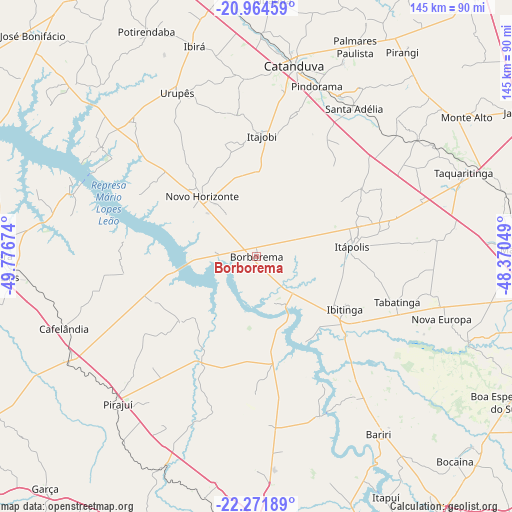
Borborema GPS coordinates[2]
21° 37' 10.992" South, 49° 4' 24.996" West
| Map corner | latitude | longitude |
|---|---|---|
| Upper-left | -20.96459°, | -49.77674° |
| Center: | -21.61972°, | -49.07361° |
| Lower-right: | -22.27189°, | -48.37049° |
| Map W x H: | 145.4×145.4 km | = 90.3×90.3mi |
| max Lat: | 2.81972° ⇑67.4% North |
| Borborema: | -21.61972° |
| min Lat: | ⇓32.6% South -33.69111° |
| min Long | Borborema | max Long |
| -72.89583° | -49.07361° | -32.41083° |
| W 27.9%⇐ | ⇒72.1% E |
Elevation
Elevation of Borborema is 424 m = 1391 ft, and this is 43.1 m = 141 ft above average elevation for this country.
| Max E: |
1603 m = 5259 ft | 44.7% |
| Borborema | 424 m 1391 ft | |
| Avg. | 380.9 m = 1250 ft | |
Min E: |
0 m = 0 ft | 55.3% |
See also: Brazil elevation on elevation.city.
Geographical zone
Borborema is located in South Torrid zone (between Equator and Tropic of Capricorn). Distance of this Southern Tropic circle is 202 km =125.5 mi to South.| Distance of | km | miles | from Borborema |
|---|---|---|---|
| Equator | 2403.9 | 1493.7 | to North |
| Tropic Capricorn | 202 | 125.5 | to South |
| Antarctic Circle | 4997.3 | 3105.2 | to South |
| South Pole | 7603.2 | 4724.4 | to South |


Nearby cities:
15 places around Borborema: (largest is in red/bold)
• Bariri
61.2 km =38 mi,  145°
145°
• Boracéia
70.6 km =43.9 mi, 154°
• Cafelândia
59 km =36.7 mi,  249°
249°
• Catanduva
54.6 km =33.9 mi,  11°
11°
• Ibitinga
29.6 km =18.4 mi,  121°
121°
• Itajobi
33.6 km =20.9 mi,  3°
3°
• Itápolis
27.1 km =16.8 mi,  84°
84°
• Lins
69.4 km =43.1 mi,  264°
264°
• Novo Horizonte
22.7 km =14.1 mi,  317°
317°
• Pindorama
51.2 km =31.8 mi,  19°
19°
• Pirajuí
57.8 km =35.9 mi,  223°
223°
• Santa Adélia
50.3 km =31.3 mi,  33°
33°
• Tabatinga
41.3 km =25.7 mi,  105°
105°
• Taquaritinga
63.5 km =39.5 mi,  68°
68°
• Urupês
51.6 km =32.1 mi,  334°
334°
Sources, notices
• [Note1] Compared only with cities in Brazil existing in our database
• [Src1] Map data: © OpenStreetMap contributors (CC-BY-SA)
• [Src2] Other city data from geonames.org with taken over terms of usage.
• [Src3] Geographical zone / Annual Mean Temperature by Robert A. Rohde @ Wikipedia
