Guaxupé geodata
Guaxupé (Minas Gerais) is a populated place; located in Brazil in America/Sao_Paulo (GMT-3) time zone. With population of 47,889 people, there are 448 cities with bigger population in this country. Compared to other cities in Brazil, 65.4% of cities are located further ↑North; 56.3% of cities are located further →East and 92.9% of cities have lower elevation than Guaxupé. Note1


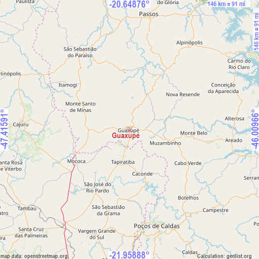
Guaxupé GPS coordinates[2]
21° 18' 19.008" South, 46° 42' 46.008" West
| Map corner | latitude | longitude |
|---|---|---|
| Upper-left | -20.64876°, | -47.41591° |
| Center: | -21.30528°, | -46.71278° |
| Lower-right: | -21.95888°, | -46.00966° |
| Map W x H: | 145.7×145.7 km | = 90.5×90.5mi |
| max Lat: | 2.81972° ⇑65.4% North |
| Guaxupé: | -21.30528° |
| min Lat: | ⇓34.6% South -33.69111° |
| min Long | Guaxupé | max Long |
| -72.89583° | -46.71278° | -32.41083° |
| W 43.7%⇐ | ⇒56.3% E |
Elevation
Elevation of Guaxupé is 858 m = 2815 ft, and this is 477.1 m = 1565 ft above average elevation for this country.
| Max E: |
1603 m = 5259 ft | 7.1% |
| Guaxupé | 858 m 2815 ft | |
| Avg. | 380.9 m = 1250 ft | |
Min E: |
0 m = 0 ft | 92.9% |
See also: Guaxupé elevation on elevation.city.
Geographical zone
Guaxupé is located in South Torrid zone (between Equator and Tropic of Capricorn). Distance of this Southern Tropic circle is 237 km =147.3 mi to South.| Distance of | km | miles | from Guaxupé |
|---|---|---|---|
| Equator | 2368.9 | 1472 | to North |
| Tropic Capricorn | 237 | 147.3 | to South |
| Antarctic Circle | 5032.2 | 3126.9 | to South |
| South Pole | 7638.1 | 4746.1 | to South |


Nearby cities:
15 places around Guaxupé: (largest is in red/bold)
• Alpinópolis
59.6 km =37 mi,  34°
34°
• Alterosa
59.4 km =36.9 mi,  83°
83°
• Areado
59 km =36.7 mi,  95°
95°
• Botelhos
49.1 km =30.5 mi,  137°
137°
• Caconde
25.9 km =16.1 mi,  164°
164°
• Cajuru
61.4 km =38.2 mi,  273°
273°
• Guaranésia
9.3 km =5.8 mi, 274°
• Itaú de Minas
63 km =39.1 mi,  356°
356°
• Mococa
35.2 km =21.9 mi,  239°
239°
• Monte Santo de Minas
30.6 km =19 mi,  294°
294°
• Muzambinho
20.9 km =13 mi,  112°
112°
• Poços de Caldas
55.9 km =34.7 mi, 163°
• São José do Rio Pardo
37.1 km =23.1 mi,  209°
209°
• São Sebastião do Paraíso
52 km =32.3 mi,  326°
326°
• Vargem Grande do Sul
61.5 km =38.2 mi,  197°
197°
Sources, notices
• [Note1] Compared only with cities in Brazil existing in our database
• [Src1] Map data: © OpenStreetMap contributors (CC-BY-SA)
• [Src2] Other city data from geonames.org with taken over terms of usage.
• [Src3] Geographical zone / Annual Mean Temperature by Robert A. Rohde @ Wikipedia
